PITTSBURGH — UPDATE 9:15 p.m.: Allegheny County officials said residents in McKeesport, White Oak and Versailles are experiencing a water shortage with outages and low water pressure.
It’s unclear what is causing this issue or when it will be fixed.
Officials told Channel 11 they are offering assistance to those who need it, and the water company is trying to find the source and determine impact.
McKeesport/White Oak/Versailles: Water shortage with outage, low water pressure and no water in some parts of all three areas. Utility working to address.
— Allegheny County (@Allegheny_Co) August 29, 2020
UPDATE 7:40 p.m.: The weekend won’t be a washout! A few scattered showers or storms will move through the area before sunset Saturday, then we’ll finally get a chance to dry out.
Severe Weather Team 11 has been tracking the remnant moisture from Laura, and the latest updates are keeping the heaviest rain south of our area.
Showers and a few storms will develop mid-morning through early afternoon, with isolated pockets of moderate rain -- especially south and east of Pittsburgh.
Cooler, more comfortable air will filter in through the evening, with skies gradually clearing. Head outdoors Sunday and enjoy a pleasant end to the weekend.
UPDATE 5:30 p.m.: PennDOT crews were out Friday afternoon cleaning drainage pipes and sewers to prepare for another round of storms.
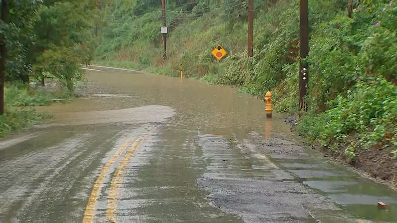
Police told Channel 11 the water level was five feet high around 3 p.m. on Seavey Road in the Northside, when a car got stuck in floodwaters. Luckily, the driver got out and wasn’t injured.
Another car got stranded on Eckert Street in Woods Run when the rain was the heaviest. That driver escaped unharmed as well as the water quickly rose.
UPDATE 5:20 p.m.: There are still about 6,800 Duquesne Light customers without power after last night’s storms continued on Friday.
The company said crews are working “around the clock” and that most of the remaining outages are expected to be repaired by late Saturday afternoon. Everyone should have power back by Saturday night.
You can read the company’s release below:
“The company reported that it hasn’t experienced any major setbacks after another line of storms came through the region this afternoon, allowing restorations to continue. With more severe weather expected this evening and into tomorrow, DLC has increased staffing to prepare for any additional outages. Anyone who experiences an outage can report it on DLC’s website, its mobile app or by calling 412-393-7000.
With many downed lines, uprooted trees and broken poles caused by the storms, DLC is warning the public to take proper precautions and avoid hazardous areas when outdoors.”
UPDATE 4 p.m.: The Tornado Warning issued for parts of Fayette County has been allowed to expire. Strong storms and heavy rains are still moving through the region.
UPDATE 3:30 p.m.: A Tornado Warning has been issued for parts of Fayette County.
Tornado Warning including Farmington PA, Deer Lake PA, Markleysburg PA until 4:00 PM EDT pic.twitter.com/1VQKRczFU3
— NWS Pittsburgh (@NWSPittsburgh) August 28, 2020
UPDATE 3:20 p.m.: Call your airline if you are flying out of Pittsburgh International Airport this evening. Due to severe weather, several flights have been delayed.
Read more here for airport operations.

UPDATE 3:06 p.m.: A new Severe Thunderstorm Warning has been issued for parts of Washington County.
Severe Thunderstorm Warning including Wellsburg WV, West Liberty WV, Burgettstown PA until 3:45 PM EDT pic.twitter.com/2cDnNZn2E3
— NWS Pittsburgh (@NWSPittsburgh) August 28, 2020
UPDATE 3 p.m.: A separate warning has been issued for parts of Fayette County.
Severe Thunderstorm Warning including Cheat Lake WV, Brookhaven WV, Fairchance PA until 3:45 PM EDT pic.twitter.com/8MDW1IzlwF
— NWS Pittsburgh (@NWSPittsburgh) August 28, 2020
County officials report significant flooding in Robinson.
Robinson: Robinson Town Centre Blvd/Park Manor Blvd - flooded roadway; Robinson Town Centre Blvd closed in both directions off of Park Manor
— Allegheny County (@Allegheny_Co) August 28, 2020
UPDATE 2:15 p.m.: The National Weather Service has issued to a Flash Flood Warning for parts of Westmoreland County.
Flash Flood Warning including Mount Pleasant PA, Youngwood PA, New Stanton PA until 5:00 PM EDT pic.twitter.com/b6CwWTkOTB
— NWS Pittsburgh (@NWSPittsburgh) August 28, 2020
UPDATE 2 p.m.: Fire officials are investigating a house that was struck by lightning in Aspinwall.

Aspinwall: 100 block Third St - house struck by lightning; fire crews investigating
— Allegheny County (@Allegheny_Co) August 28, 2020
UPDATE 1:45 p.m.: Witnesses said a man had to be rescued after he became stuck in his car as flash flooding quickly submerged it.

UPDATE 1:35 p.m.: Officials in Shaler Township report Seavey Road is close due to flooding.
HAPPENING NOW: Seavey Rd between Shaler and Millvale is flooded. Officers tells me the water was 5 feet high at one point, but has come down since. It’s blocked in both directions pic.twitter.com/u0LPBmWG5P
— Aaron Martin (@WPXIAaronMartin) August 28, 2020
UPDATE 1:30 p.m.: Allegheny County officials are dealing with a number of high water issues and a number of roads are closed throughout the area.
McKees Rocks: 900 block Page St - residences flooding
— Allegheny County (@Allegheny_Co) August 28, 2020
Baldwin Borough: Streets Run Rd at Brentwood Rd - roadway closed due to flooding
— Allegheny County (@Allegheny_Co) August 28, 2020
McKees Rocks: 1200 block Chartiers Ave - vehicle stuck in flood water
— Allegheny County (@Allegheny_Co) August 28, 2020
McKees Rocks: Multiple calls reporting flood water entering residences, including St. John Street and Broadway Ave
— Allegheny County (@Allegheny_Co) August 28, 2020
UPDATE 1:28 p.m.: Duquesne Light reports 11,545 customers are without power as of 1:03 p.m. as heavy thunderstorms moved through the region.
UPDATE 1:16 p.m.: A Flash Flood Warning has been issued for parts of Allegheny, Westmoreland and Indiana counties until 6:45 p.m. This includes Imperial, Pittsburgh, Plum, Delmont, Greensburg, Derry and Blairsville among other areas.
Flash Flood Warning continues for Pittsburgh PA, Monroeville PA, Plum PA until 6:45 PM EDT pic.twitter.com/Grg5s8cETo
— NWS Pittsburgh (@NWSPittsburgh) August 28, 2020
UPDATE 12:45 p.m.: A Flash Flood Warning has been issued for parts of Allegheny and Westmoreland counties until 6:30 p.m. after heavy rains and storms pushed through the area.
Flash Flood Warning continues for Bethel Park PA, West Mifflin PA, McKeesport PA until 6:30 PM EDT pic.twitter.com/thyTDI1ERb
— NWS Pittsburgh (@NWSPittsburgh) August 28, 2020
UPDATE 10:55 a.m.: A Flood Advisory is in effect until 1:45 p.m. for part of the area.
As I said, concerned about flooding. Flood Advisory issued for shaded area until 1:45. Some of this could get upgraded to a Flash Flood Warning later.
— Scott Harbaugh (@WPXIScott) August 28, 2020
Interactive Radar: https://t.co/FZ9C6meUjq pic.twitter.com/rBf2fHnA6g
UPDATE 10:50 a.m.: Severe thunderstorms have already developed during the morning hours. Rain coverage will continue to increase this afternoon and evening, with strong cells expected. These cells could include heavy rain that could lead to flooding, damaging straight-line winds and hail. Isolated tornadoes could also develop. Any training cells could provide 1 to 2 inches of rain per hour.
FLASH FLOOD concerns along I-80 corridor the next several hours with prolonged periods of heavy rain. Follow @JessicaWPXI for updates all day.
— Scott Harbaugh (@WPXIScott) August 28, 2020
Interactive radar: https://t.co/FZ9C6meUjq pic.twitter.com/vKdRNED3P5
Severe Weather Team 11 will continue to track severe weather threats today and will provide updates when needed.
If you want to receive alerts about weather, download our Severe Weather Team 11 app.
Showers and storms are expected tomorrow, with increased moisture from the remnants of Laura and as a cold front tracks through the area. The risk for strong to severe storms will mainly be during the afternoon and early evening. Later in the night, drier and cooler air will filter in behind the cold front.
Better weather is set for day two of the weekend. Sunday brings back sunshine and cooler temperatures.
UPDATE 10:35 a.m.: A Severe Thunderstorm Warning is in effect until 11:15 a.m. for parts of Indiana, Jefferson, Armstrong and Clarion counties.
Severe Thunderstorm Warning is issued for Indiana, Jefferson, Armstrong, Clarion counties until 11:15 AM. The storm is moving east at 35 mph. Hazards include wind gusts up to 60 mph. #PAwx pic.twitter.com/nujtxJaQPu
— Jessica Faith (@JessicaWPXI) August 28, 2020
UPDATE 9:45 a.m.: A new Severe Thunderstorm Warning is in effect until 10:30 a.m. for parts of Armstrong, Butler, Clarion and Venango counties.
New SEVERE THUNDERSTORM WARNING until 10:30.
— Scott Harbaugh (@WPXIScott) August 28, 2020
Get alerts: https://t.co/SNtbZ2oeIx pic.twitter.com/PkjpWLYV57
UPDATE 9 a.m.: A Severe Thunderstorm Warning is in effect until 9:45 a.m. for parts of Butler, Lawrence, Mercer and Venango counties.
WEATHER ALERThttps://t.co/pmwncDzuHb | https://t.co/5TuINuXud7 | https://t.co/jMjzNKJQ6v | https://t.co/kXBEdLY2tR pic.twitter.com/Vyu218DMM5
— WPXI (@WPXI) August 28, 2020
ORIGINAL STORY: It will be an active couple of days, with several rounds of showers and storms crossing the area through Saturday.
The good news is we’ll see some much-needed rain to help ease the drought across much of the area. The bad news is some of the storms will be severe, with damaging winds in excess of 60 mph.
Thunderstorms will fire up through the day Friday, with several rounds crossing the area. Storms could be strong at times, with damaging winds, hail and flooding rain. Repeated rounds of heavy rain over the same areas will make localized flooding a bigger concern.
If you want to receive alerts about weather, download our Severe Weather Team 11 app.
A cold front approaching the area this weekend coupled with tropical moisture from the remnants of Hurricane Laura will provide the potential for heavy rain late Friday night and Saturday. The latest track brings the system close to our area late Friday night through Saturday afternoon.
Pockets of heavy rain could cause localized flooding, with some areas getting more than 2 inches of rain. Right now, the heaviest rain should be south of Pittsburgh.
Stay with Severe Weather Team 11 as we track the severe weather threats for your neighborhood.
TRENDING NOW:

Cox Media Group
/cloudfront-us-east-1.images.arcpublishing.com/cmg/XCUXZC2XYZHCRGNNGKFEX6U3LQ.png)


