PITTSBURGH — Snow is winding down across the region, but many roads could be snow-covered and icy.
UPDATE 6:30 p.m.: Keep the ice scrapers and snow shovels handy for the next few days. Two more rounds of snow are headed our way.
Temperatures will be in the teens early Wednesday and it will set the stage for wet roads and sidewalks to refreeze. Watch for icy spots as you get on your way. Snow will return late in the day and continue through early Thursday leaving another 1 to 3 inches in its wake. Higher amounts are possible to the south and east of Pittsburgh.
Another wave of snow develops late Thursday, keeping roads snowy for the Friday morning commute.
Colder temperatures and snow chances continue through the weekend. Stay with Severe Weather Team 11 as we bring you the latest updates and details on when wintry conditions will have the biggest impact on your plans.
Icy spots likely tonight, early Wednesday. 2 more rounds of snow before the weekend. LIVE forecast Channel 11 News 5pm. pic.twitter.com/SjqAJLjqOC
— Stephen Cropper (@WPXICropper) February 9, 2021
UPDATE 6:15 p.m.: A warming shelter will be open in Pittsburgh.
28 Below Emergency Warming Center at Abiding Missions will be open from 7 a.m. to 3 p.m. The shelter is located at 731 Excelsior Street. Call 412-481-1161 for more details.
UPDATE 6 p.m.: The sound of shovels and snowblowers filled the air around Greensburg after about 6 inches of snow fell.
“I’m about done with it,” said John Dalicandro.
“When I first looked out, I knew we were going to have snow but I didn’t realize how much was down here,” said Renee Stewart.
Public works officials in Greensburg said they were concerned about their salt supply with more snow in the forecast.
“I’ve ordered some salt, haven’t received anything yet. I probably got a little over 400 tons sitting there and it’ll get me by through the week and everything,” said Tom Bell with Greensburg Public Works. “I’m not panicking yet.”
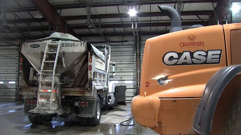
UPDATE 5:30 p.m.: Crews in Cranberry Township said they’re ready to battle the threat of black ice overnight as temperatures plummet.
The public works department had two types of trucks on the road: one that mixes brine with the road salt and another that just spreads salt.
Police said they will keep in touch with road crews to let them know when and where salt trucks are needed.
UPDATE 5:00 p.m.: Trash and recycling collections were suspended or delayed in the City of Pittsburgh and Whitehall Borough among other places.
Martin Rafanan said he had to shovel at least twice.
“Buses were struggling to get up this hill. Normally, they make it up pretty easily,” he said.
“We’re doing our best to clear the roads and our crews will be out there for 24-days, if needed,” said Allegheny County Public Works director Stephen Shanley.
It’s a pattern that we could see repeated in the coming days with more snow and frigid temperatures in the forecast.
“If there’s ice, we all struggle. But if it’s like today and we get a bit of warm weather and a bit of melt off, it’s okay,” Rafanan said.
UPDATE 11:45 a.m.: We’ll continue to see a few snow showers through Tuesday afternoon. Expect reduced visibility in spots. Highs will be in the upper 20s and fall to the mid-teens overnight. Watch for slick spots on untreated surfaces.
Wednesday will bring a mostly cloudy sky with highs in the mid-20s and light northeast winds. Snow will once again push in from the south by Wednesday evening, with snow continuing into early Thursday morning.
And man, did we get it! Some places even over-performed! Had some 6" reports out there! #PAwx https://t.co/4rj6GH9FLe
— Danielle Dozier WPXI (@DanielleDozier) February 9, 2021
Periods of snow showers will continue through the weekend with below-average temperatures expected.
Stay with Severe Weather Team 11 as we track your forecast.
UPDATE 11:25 a.m.: The City of Pittsburgh Department of Public Works Environmental Services Bureau has canceled garbage and recycling collection Tuesday because of the weather.
Workers will attempt to collect all delayed garbage on Wednesday, but with winter weather expected to continue through the week, residents should be prepared for their normal pickup to be delayed one day.
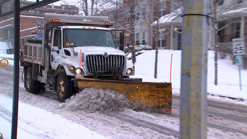
UPDATE 11:10 a.m.: A winter storm has largely moved out of the Pittsburgh area, but cleanup is still well underway on the city’s North Side.
Untreated side streets and sidewalks are a big problem.
The snow fell consistently from about 2 a.m. until 10 a.m. on the North Side, where drivers struggled to make it up and down streets.
The Pittsburgh Department of Public Works deployed more than 45 trucks to treat and plow the roads, but the snow came down so fast that it was hard to keep up.
UPDATE 10:58 a.m.: PennDOT has lifted the speed limit restrictions that were in place on several roadways in the region.
Speed limits were reduced to 45 mph on all interstates and several other routes in the region. All speeds are restored to their usual posted limits.
PennDOT is continuing to treat roadways in the area and will continue until roads are clear.
UPDATE 10:50 a.m.: Winter weather advisories for the area have been cancelled.
UPDATE 8:10 a.m.: Snow will begin to wind down across much of the area, but many roads will be snow-covered and icy for hours to come.
Snow came down at a good clip overnight, making it hard for road crews to keep up early this morning.
A total of 3-6 inches of snow will fall across much of Allegheny, northern Washington, northern Westmoreland and southern Indiana counties. One or two spots could pick up a bit more.
Most of the rest of the area will see 1-3 inches, with less than an inch in Venango, Mercer, Greene and Monongalia counties.
Some snowfall amounts through 8am. How much do you have in your yard (new snow)?
— Scott Harbaugh (@WPXIScott) February 9, 2021
Interactive radar: https://t.co/FZ9C6meUjq pic.twitter.com/tyduLCrOqI
The afternoon commute will be much easier, with only lingering flurries for much of the area.
It will be an active weather week with another snowmaker moving in Wednesday afternoon and lingering into Thursday, and more snow later this weekend.
Stay with Severe Weather Team 11 as our team of meteorologists tracks when snow will have the biggest impact on your plans.
UPDATE 8 a.m.: A tree fell on wires in Ross Township, knocking out power to the Waldorf Park apartments on McKnight Circle.
Tree down on wires on McKnight Circle in Ross. Power out in Waldorf Park apartments. #WPXI #PGH #Pittsburgh #SNOW @WPXITraffic @WPXIScott pic.twitter.com/LrbChLGFkH
— Tony Ruffolo (@WPXITonyRuffolo) February 9, 2021
UPDATE 7:45 a.m.: There have been two crashes on Interstate 79 southbound, near Carnegie.
WE'VE HAD TWO CRASHES on Interstate 79 Southbound near Carnegie - Keep In Mind that Elevated Areas, Such As This Area, Could Be Icy. #PittsburghTraffic #wpxi https://t.co/UyYsfsftyh pic.twitter.com/Mw7lUOq0Cq
— WPXI Traffic (@WPXITraffic) February 9, 2021
UPDATE 7 a.m.: A multi-vehicle crash on Interstate 79 South, near Carnegie, has the right lane blocked.
UPDATE 6:42 a.m.: The Pennsylvania Department of Transportation is temporarily reducing the speed limit on several roadways in the region.
PennDOT is urging drivers to avoid unnecessary travel, but those who must head out will see speeds reduced to 45 mph on the following highways:
Allegheny County
- Interstates 79, 376 (Parkways East and West), 279 (Parkway North), and 579
- State Route 28
Beaver County
- Interstate 376 (Beaver Valley Expressway)
Lawrence County
- Interstates 79 and 376
- State Route 422
Stay ahead of the storm by downloading our FREE Severe Weather Team 11 app. It’ll keep you connected to Channel 11 News, our local forecasts, live radar and school closings - even if your power goes out.
UPDATE 6:15 a.m.: Many roads in the Pittsburgh area are snow-covered and slick. Crews are out working to clear them, but the snow keeps coming down.
If you have to head out, the Pennsylvania Department of Transportation asks drivers to slow down and give plows space.
Reports of crashes and cars getting stuck continue to come in.
All the roads I’ve been on since 3 AM have looked like this. 6:25 am now and this is 136 in East Washington. @PennDOTNews says “if you didn’t have to be out don’t be out.” (I have to be out to show you why you might want to just stay home this morning & watch @WPXI) pic.twitter.com/kHuRY58URJ
— Alyssa Raymond (@AlyssaRaymond) February 9, 2021
SOME GOOD REMINDERS: No Matter the Time of Day, Wipers On = Headlights On. Don't Just Brush Snow Off Of Your Windshield, Clear the Entire Car, Roof Too! AND ...Plows Often Move in Tandem Chains - Don't Get Between Them. #PittsburghTraffic #wpxi https://t.co/UyYsfsftyh pic.twitter.com/h9iuEEzzXe
— WPXI Traffic (@WPXITraffic) February 9, 2021
UPDATE 5:57 a.m.: More than 250 school districts, daycares and other businesses have closed or delayed starts this morning due to the snow.
You can get the full list HERE.
UPDATE 5:18 a.m.: On Channel 11 Morning News at 5:18 a.m., Meteorologist Scott Harbaugh explained why Pittsburgh and Allegheny County are getting more snow than surrounding areas.
It’s called frontogenesis.
Learn more in the video below.

UPDATE 5 a.m.: A truck rolled onto its side at Anthony and Lydia street in Carnegie. The driver is OK.
Truck rolled onto its side after trying to get up this hill. Happened around 2:40 AM. Anthony & Lydia Streets in Carnegie. Very close to the Parkway. Coming off the Heidelberg exit. @WPXI pic.twitter.com/Vh3G8786U1
— Alyssa Raymond (@AlyssaRaymond) February 9, 2021
ORIGINAL STORY: It will be a very slow morning commute Tuesday with snow-covered roads and delays.
Snow will come down at a good clip, making it hard for road crews to keep up through the morning commute.
Three to six inches of snow will fall across much of Allegheny, northern Washington, northern Westmoreland and southern Indiana counties. One or two spots could pick up a bit more.
Most of the rest of the area will see 1-3 inches, with less than an inch in Venango, Mercer, Greene and Monongalia counties.
**UPDATED** Snow total forecast through this morning. Live Team 11 coverage kicks off on Channel 11 Morning News from 4:30-7am.
— Scott Harbaugh (@WPXIScott) February 9, 2021
Watch live: https://t.co/mmXOytnrtc
Interactive radar: https://t.co/FZ9C6meUjq pic.twitter.com/KnRkR2w0Mb
The afternoon commute will be much easier, with only lingering flurries for much of the area.
It will be an active weather week with another snowmaker moving in Wednesday afternoon and lingering into Thursday, and more snow later this weekend.
Stay with Severe Weather Team 11 as our team of meteorologists tracks when snow will have the biggest impact on your plans.
Stay ahead of the storm by downloading our FREE Severe Weather Team 11 app. It’ll keep you connected to Channel 11 News, our local forecasts, live radar and school closings - even if your power goes out.
TRENDING NOW:
Cox Media Group
/cloudfront-us-east-1.images.arcpublishing.com/cmg/XCUXZC2XYZHCRGNNGKFEX6U3LQ.png)


