PITTSBURGH — Freezing rain and rain are heading out. Bitter wind chills are moving in.
UPDATE 11:37 a.m.: Snow showers are moving through the area. Areas of freezing drizzle are also possible.
11:37 a.m. - Snow showers are moving through the area. Areas of freezing drizzle may also occur. I'm on @wpxi at Noon w/your afternoon forecast. #PAwx #Pittsburgh pic.twitter.com/jcYNkqwpbC
— Danielle Dozier WPXI (@DanielleDozier) February 16, 2021
UPDATE 6:10 a.m.: The winter storm warning that was in effect for the area has been cancelled. An ice storm warning remains in effect for Cambria, Garrett and Somerset counties.
CANCELED! Winter Storm Warning canceled. So, now I'll focus on Thursday's snow. :-) Live now on @WPXI ---> https://t.co/mmXOytnrtc pic.twitter.com/jHNY2Wi0HL
— Scott Harbaugh (@WPXIScott) February 16, 2021
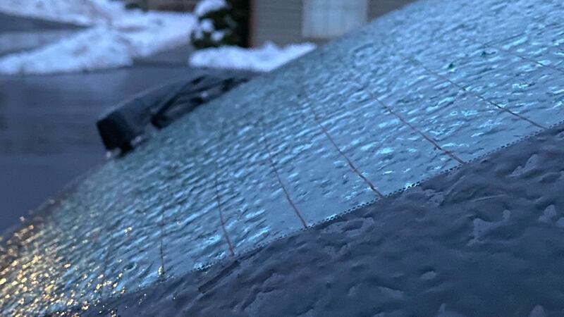
UPDATE 5:40 a.m.: Freezing rain and rain are heading out. Bitter wind chills are moving in.
Overnight rain and freezing rain have left a coating of ice on many trees and powerlines. Power outages are still possible this morning as temperatures plunge back into the 20s.
Winds will gust to 30 mph at times Tuesday, sending wind chills into the single digits during the afternoon.
Wednesday will be a quiet day before our next round of winter weather rolls in for Thursday. Many areas will see accumulating snow Thursday.
Stay with Severe Weather Team 11 as we update the timing of the snow’s arrival and how much you will have in your driveway by Thursday evening.
UPDATE 5:30 a.m.: Speed limit restrictions on roadways in the region have been lifted by the Pennsylvania Department of Transportation.
UPDATE 4 a.m.: Ice is the biggest concern Tuesday morning for the Port Authority’s light rail service.
Tracks could be coated, and cables could potentially be pulled down by the weight of ice.
A Port Authority spokesperson said crews would be working throughout the night to fix icing problems on the T system.
On Monday night, riders were forced to wait at the Washington Junction in Bethel Park. Their trip to Beechview was delayed after ice formed on the overhead lines.
A shuttle bus was brought in to help get riders between South Hills Junction and Overbook.
There were also delays on the red line in the Mount Lebanon area.
As of 4 a.m. Tuesday, light rail service appeared to be operating at a normal rate.
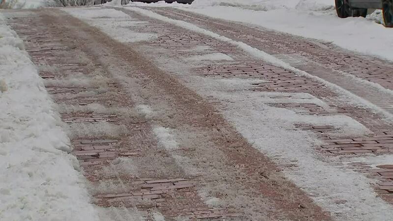
UPDATE 10:45 p.m.: Save some time to scrape your windshield early Tuesday, as a wintry mix of freezing rain continues off and on overnight. Untreated surfaces will be icy, and even treated surfaces that are not heavily traveled could be icy as well.
Colder air will sweep in through the morning, pushing temperatures into the 20s through the day. Winds will also pick up, making it feel even colder.
Temperatures will crash into the single digits overnight, so wet roads and sidewalks will turn icy again early Wednesday.
Severe Weather Team 11 is also tracking another wintry system set to move in Thursday, bringing more snow and wintry mix.
UPDATE 10:25 p.m.: There are more than 1,300 Duquesne Light without power -- 532 of them in Bellevue.
First Energy is reporting 1,199 outages, mostly in Greene County.
UPDATE 9 p.m.: The city of Pittsburgh reminded residents of the restrictions implemented by PennDOT during these icy conditions.
The current restrictions on on I-79, I-376, I-279, I-579, I-70, Route 28, and Route 422 now follow Tier 1 of the commonwealth’s weather event vehicle restriction plan. Check https://t.co/mBFWLuqom8 for the latest updates. pic.twitter.com/mWd8EjGNRd
— 511PA Pittsburgh (@511PAPittsburgh) February 15, 2021
UPDATE 8:40 p.m.: Port Authority confirmed a trolley car got stuck on the tracks on Broadway Avenue in Beechview because the overhead lines are getting icy.
The car was moving again within about 15 minutes, but you can see sparks flying in the air.
Officials told us they anticipate having similar issues throughout the night.
UPDATE 8:15 p.m.: Snow moves back into the area this evening, changing to sleet and freezing rain for many areas from I-70 north. Travel will be difficult, and freezing rain will create dangerous conditions where it falls.
Areas north of Pittsburgh will see more snow before changing to a wintry mix tonight.
Looking Ahead: While temperatures may rise slightly overnight, they'll fall again through the day Tuesday. Tuesday afternoon will bring temps in the 20s, w/gusts up to 30 mph. #PAwx
— Danielle Dozier WPXI (@DanielleDozier) February 16, 2021
A transition to rain is also possible as temperatures slowly climb this evening; however, ground temperatures will still be cold enough for icy spots.
Trees and power lines may become ice covered in some areas, leading to power outages.
UPDATE 8 p.m.: Due to the winter weather, PennDOT announced more Tier 1 vehicle restrictions on interstates and highways, effective now:
- The entire length of Route 22
- The entire length of Route 33
- The entire length of Interstate 70
- The entire length of Interstate 78
- Interstate 80 from Route 11/15 to the New Jersey border
- The entire length of Interstate 81
- The entire length of Interstate 83
- The entire length of Interstate 84
- Interstate 99 from the PA Turnpike to Interstate 80
- The entire length of Interstate 180
- The entire length of Interstate 380
UPDATE 7:15 p.m.: We have had about two consecutive hours of freezing rain in the Pittsburgh area.
Elevated surfaces are iced over, so driving conditions will be very difficult over the next few hours.
About two straight hours of freezing rain here in the #Pittsburgh area. Elevated surfaces are iced over. Take it easy tonight, everyone! #PAwx #wpxistorm pic.twitter.com/7vPBFX68xA
— Danielle Dozier WPXI (@DanielleDozier) February 16, 2021
UPDATE 6:10 p.m.: PennDOT is now reducing speed limits to 45 miles per hour on multiple major roadways.
Allegheny County
- Interstates 79, 376 (Parkways East and West), 279 (Parkway North), and 579
- State Route 28
Beaver County
- Interstate 376 (Beaver Valley Expressway)
Lawrence County
- Interstates 79 and 376
- State Route 422
UPDATE 5:50 p.m.: The freezing rain is starting to mix in with snow in western Pa., creating slippery conditions on roadways throughout the region.
Starting to rain here in Lawrenceville @wpxi pic.twitter.com/B00HEhDBfj
— Liz Kilmer (@LizKilmerWPXI) February 15, 2021
The ICE that you see Coating this PennDOT Camera on I-70 at the State Line is the Same ICE that is Coating Any Untreated Surfaces. Conditions are Turning Slick, Quickly. #PittsburghTraffic #WPXI https://t.co/UyYsfsftyh pic.twitter.com/dRHfesVm9w
— WPXI Traffic (@WPXITraffic) February 15, 2021
#HAPPENINGNOW: We’re getting some freezing 🌧 in Cranberry Township. LIVE update coming up at 6:25 p.m. on @WPXI pic.twitter.com/NBCDIreWpx
— Jillian Hartmann WPXI (@JillianWPXI) February 15, 2021
UPDATE 5:20 p.m.: Freezing rain is starting to fall across the area, including Beaver and Washington counties.
It will move north into Allegheny soon.
The freezing rain is coming down in Beaver County @WPXI pic.twitter.com/ksW2dqxEVE
— Amy Hudak (@amy_hudak) February 15, 2021
Freezing Rain and Sleet are moving into Washington County, and headed North. You Can See It on this PennDOT Camera, in the Bridgeville area. Use Caution. Join Us on Channel 11 News for the latest. #PittsburghTraffic #wpxi https://t.co/UyYsfsftyh pic.twitter.com/3PVe1Dg2Pn
— WPXI Traffic (@WPXITraffic) February 15, 2021
UPDATE 4:40 p.m.: A teen fell through the ice into Lake Elizabeth while playing hockey with his friends -- near Allegheny General Hospital.
We just saw a teen fall in Lake Elizabeth while playing Hockey in Allegheny Commons West Park. His friends laughed while pulling him to safety. @WPXI
— Ryan Houston WPXI (@WPXIRyanHouston) February 15, 2021
UPDATE 4:35 p.m.: Earlier today, snow plows were out in force at the Pittsburgh International Airport.
Crews have been preparing in advance and coordinating snow and ice removal with the airlines. They’re taking no chances after the Delta flight slid off a taxiway and almost into a ravine last week.
The FAA is investigating that accident to determine what caused the plane to skid off the runway -- and if snow removal could have been an issue.
There have been a few canceled or delayed flights Monday, mostly because of weather in other parts of the country -- like Texas.
You can check your flight status HERE.
UPDATE 4:30 p.m.: The winter storm has crossed into Pennsylvania. It will quickly move through the region over the next several hours.
4:21 pm - Here it comes! There's a lot of moisture headed our way. Pink shows where freezing rain could be occurring and purple is mixed. #PAwx #Pittsburgh #wpxi pic.twitter.com/73AFb3DjKL
— Danielle Dozier WPXI (@DanielleDozier) February 15, 2021
SPC highlighting our area for 0.05-0.10" freezing rain per 3 hours with a period of potentially 6 hours total. Some sleet and snow may also mix in. Tracking on @wpxi! #PAwx #Pittsburgh pic.twitter.com/MWXl070yO8
— Danielle Dozier WPXI (@DanielleDozier) February 15, 2021
UPDATE 3:50 p.m.: Severe Weather Team 11 provided a few things you should know about ice, as the winter storm fast approaches:
- One-half inch of ice on power lines can add 500 pounds of extra weight
- Ice can increase the weight of branches by 30 times
- One-quarter to one-half inch of ice can start to damage trees and power lines
- High winds can cause power lines to sway, furthering the problem
UPDATE 3:00 p.m.: Snow moves back into the area this evening, changing to sleet and freezing rain for many areas from I-70 north. Travel will be difficult, and freezing rain will create dangerous conditions where it falls. Areas north of Pittsburgh will see more snow before changing to a wintry mix tonight.
A transition to rain is also possible as temperatures slowly climb this evening, however, ground temperatures will still be cold enough for icy spots. Trees and power lines may become ice covered in some areas, leading to power outages.
Charge portable devices and stay with Severe Weather Team 11 and Chanel 11 News for the latest.
UPDATE 1:55 p.m.: Speed reductions on some area roads have been lifted.
The 45 mph speed reductions have been lifted on I-79, I-376, I-279, I-579, Route 28, and Route 422 Check https://t.co/mBFWLuqom8 for the latest updates. pic.twitter.com/U58iRvdBU5
— 511PA Pittsburgh (@511PAPittsburgh) February 15, 2021
UPDATE 1:50 p.m.: Allegheny County Public Works deployed 27 salt trucks at midnight Monday. The snow accumulation across the county was on the lower end of predictions. Crews did not receive any reports this morning of problem areas on the roadways in which the county is responsible.
With more snow and ice on the way, Allegheny County Public Works will continue to have at least 27 salt trucks out on county roads and bridges until the storm ends tomorrow. If needed, more drivers will be brought in to make sure there is complete coverage of the roadways.
During the freezing rain, crews will be laying down salt covered with liquid calcium chloride to manage the possible ice accumulation.
It takes crews between one and two hours to complete their routes and another hour to return to the garage to refill with salt. People are encouraged to stay home, if possible.
If you need to be on the road, plan extra time for your commute and leave enough room for salt truck drivers.
UPDATE 1:42 p.m.: Pennsylvania Gov. Tom Wolf is urging Pennsylvanians to be aware of winter weather and avoid travel.
The snow and ice could make for treacherous travel, especially this evening and overnight. As a result, Gov. Wolf is asking people to consider avoiding or reducing their travel.
“Safety is paramount during these ongoing winter storms,” Gov. Wolf said. “State agencies, including PennDOT and the Pennsylvania Emergency Management Agency (PEMA), and local municipalities are working to prepare roads and clear snow and melt ice to allow for necessary travel, but the more we stay off the roads, the easier their jobs will be and the safer we will make our state.”
UPDATE 1:30 p.m.: Pittsburgh officials said public works is “adequately staffed” with enough salt.
MORE:
— Liz Kilmer (@LizKilmerWPXI) February 15, 2021
City spokesperson says public works is "adequately staffed" with enough salt. We received this statement @wpxi pic.twitter.com/P2lgmOZckm
UPDATE 12:30 p.m.: We’re starting to get a look at some of the snow totals across the area after round one.
Snow totals from Round 1. I'm timing in round 2 and who sees all snow vs. who gets an icy mix. See you on Channel 11 News at Noon
— Scott Harbaugh (@WPXIScott) February 15, 2021
Watch live: https://t.co/mmXOytnrtc pic.twitter.com/PPgdwEPExK
UPDATE 11:50 a.m.: Interstate 79 northbound remains closed between Route 422 in New Castle to Route 108 in Slippery Rock.
The 7-mile stretch of the highway is closed because a tractor-trailer jackknifed earlier in the morning.
No one was hurt.
Pennsylvania State Police are at the scene. PennDOT crews are also there to help with traffic control.
A tow truck is being brought in to remove the tractor-trailer from the roadway.
UPDATE 10:50 a.m.: The Pennsylvania Department of Transportation has temporarily reduced the speed limit on Interstate 80 from the Ohio state line through Clearfield County.
PennDOT is urging drivers to avoid unnecessary travel, but those who must head out will see speeds reduced to 45 mph.
UPDATE 10:45 a.m.: In just a few hours, precipitation in Pittsburgh’s North Side went from nothing to freezing drizzle and then snow.
As the snow picked up, it began sticking to sidewalks and streets. There were whiteout conditions at times.
People walking and driving quickly noticed the changing conditions, which slowed things down.
“The roads are kind of sketchy. I was actually supposed to have a meeting in the office downtown, but we actually opted to cancel that. Obviously, it’s a little treacherous for people who have to travel,” Letha Mills, who lives in the North Side, said.
The city of Pittsburgh said its crews are prepared with roughly 70 trucks that will be out salting and plowing throughout the day.
Allegheny County has more than 25 trucks deployed.
UPDATE 10:20 a.m.: The Pennsylvania Department of Transportation is temporarily reducing the speed limit on several roadways in the region.
PennDOT is urging drivers to avoid unnecessary travel, but those who must head out will see speeds reduced to 45 mph on the following highways:
Allegheny County
- Interstates 79, 376 (Parkways East and West), 279 (Parkway North), and 579
- State Route 28
Beaver County
- Interstate 376 (Beaver Valley Expressway)
Lawrence County
- Interstates 79 and 376
- State Route 422
UPDATE 10:05 a.m.: Interstate 79 northbound is closed between exit 99 (US 422 - NEW CASTLE/BUTLER) to exit 105 (PA 108 - SLIPPERY ROCK), the Pennsylvania Department of Transportation announced.
I-79 NORTHBOUND BEING SHUT-DOWN from Rt 422 / New Castle / Butler to Route 108 /Slippery Rock. #PittsburghTraffic #WPXI pic.twitter.com/pViKmENOlv
— WPXI Traffic (@WPXITraffic) February 15, 2021
UPDATE 9:30 a.m.: Road conditions are deteriorating as snow picks up across the area.
Conditions worsening. Here’s a look at the parkway heading out of the city toward Ross Park Mall. @WPXI #Weather #Snow #WpxiStorm #Pittsburgh pic.twitter.com/ZtN7QiwF2i
— Mike Holden (@WPXIMikeHolden) February 15, 2021
#WPXIStorm - road conditions deteriorating as snowfall increases. This is I79southbound just before the I279 split. #WPXI #PGH #Pittsburgh #VIDEO @WPXITraffic @WPXIScott pic.twitter.com/VUWx3mT9gz
— Tony Ruffolo (@WPXITonyRuffolo) February 15, 2021
UPDATE 8:40 a.m.: There are heavy delays on Interstate 79 southbound coming from Warrendale after an accident involving a car that spun into the median. There is also a jackknifed tractor-trailer.
#Accident - tractor trailer jackknifed on I79 southbound just past the Rt910/Wexford exit. One car spun out in the median. #WPXI #PGH #Pittsburgh @WPXITraffic pic.twitter.com/iCYyW3Hi7u
— Tony Ruffolo (@WPXITonyRuffolo) February 15, 2021
HEAVY DELAYS on I-79 South coming from Warrendale to the Split due to an Accident Involving a Car Spun into the Median and Jack-Knifed Tractor Trailer. #PittsburghTraffic #wpxi https://t.co/UyYsfsftyh pic.twitter.com/R7uDfJfI3P
— WPXI Traffic (@WPXITraffic) February 15, 2021
ORIGINAL STORY: Snow, freezing rain and plain rain -- it will be a kitchen sink event with something for everyone through early Tuesday morning.
A winter storm warning is in effect for much of the area until 1 p.m. Tuesday. The warning is in effect for the combination of ice and snow that will come in two different rounds.
A winter weather advisory will go into effect at the same time for Monongalia, Preston and Fayette counties.
Snow will start early Monday morning. There could be a band of moderate to heavy snow that sets up through the area, which will limit visibility and make driving dangerous as snow sticks to untreated surfaces. Overall, up to two inches of snow will be possible by noon Monday.
If you want to receive alerts about weather, download our Severe Weather Team 11 app.
There will be isolated spots of snow Monday afternoon, but the second round of steadier snowfall will start Monday evening. Snow will mix with freezing rain or sleet.
Right now, the heaviest snow totals will fall across our northwest counties, with lesser amounts in our far southeast counties. Significant icing will be possible over Allegheny, Washington, Westmoreland, Butler, Armstrong and Indiana counties, encasing trees and powerlines.
Continue to check in with Severe Weather Team 11 as the forecast evolves.
TRENDING NOW:
Cox Media Group
/cloudfront-us-east-1.images.arcpublishing.com/cmg/XCUXZC2XYZHCRGNNGKFEX6U3LQ.png)


