
PITTSBURGH — Our area was hit hard with severe storms on Tuesday.
PHOTOS: Heavy rain, thunderstorms move through Pittsburgh area Tuesday afternoon
UPDATE 10:19 a.m.
West Penn Power provided an update on power outages.
Crews are working as quickly + safely as possible to restore service to customers after last night's storms, which produced rain and powerful winds that damaged trees, power lines & poles. About 16,300 customers remain without service, down from about 34,000 total impacted.
— West Penn Power (@W_Penn_Power) May 4, 2022
1/3 pic.twitter.com/EPOGWUNK4G
As crews continue to clear hazards and restore power, customers are reminded to stay at least 30 feet away from downed lines and report them by calling 911.
— West Penn Power (@W_Penn_Power) May 4, 2022
Thanks for your patience during this process!
3/3 pic.twitter.com/iN0yaw2cfK
UPDATE 7:18 a.m.
The National Weather Service in Pittsburgh will be conducting a storm survey in Washington County to assess possible tornado damage.
We will be conducting a storm survey in Washington County PA today to assess possible tornado damage. We'll have results of the survey later today. https://t.co/61n6rsB4kr
— NWS Pittsburgh (@NWSPittsburgh) May 4, 2022
UPDATE 7:07 a.m.:
West Penn Power said their crews are out assessing damage right now, and can not give an estimate yet on when power will be restored.
Customers are reminded to STAY AWAY from downed lines and report them by calling 9-1-1. Crews are actively working to assess damage, clear hazards and provide restoration times for customers impacted by yesterday evening's storms. We’ll share estimates as soon as possible! pic.twitter.com/SKN2hJYVZ4
— West Penn Power (@W_Penn_Power) May 4, 2022
UPDATE 6:30 a.m.:
Norwin School District has now moved to a flexible instruction day
UPDATE 6:22 a.m.
Duquesne Light said they currently still have 350 customers without power in Allegheny County. Power is expected to be restored to all customers by 5 p.m., some even earlier.
UPDATE 5:52 a.m.:
Bower Hill Elementary School will move to remote instruction. All other schools in the district will be in person.
REMOTE INSTRUCTION: for Bower Hill Elementary School in the Peters Township School District. That's the only school in the district on remote instruction; all other Peters Township School District students should report to school in person. pic.twitter.com/2TujlBbrIO
— WPXIJennifer Tomazic (@JenniferTomazic) May 4, 2022
UPDATE 5:47 a.m.
Two busy roads in Upper St. Clair remain closed. Avoid these portions of Bethel Church and McMurray roads:
HEADS UP: Two Heavily Traveled Roads Remain CLOSED in Upper St Clair due to strom damage. Avoid these portions of Bethel Church Rd and McMurray Rd. #PittsburghTraffic #WPXI https://t.co/UyYsfsftyh pic.twitter.com/S8j3v5cxU5
— WPXI Traffic (@WPXITraffic) May 4, 2022
UPDATE 5:30 a.m.:
The Norwin School District will be on a 2-hour delay Wednesday because of road closures and power outages.
Due to road closures and power outages, the Norwin School District is operating on a 2-hour delay schedule today, Wednesday, May 4th with modified kindergarten. Visit https://t.co/e3X61Z8sUO for additional information.
— Norwin School District (@NorwinSD) May 4, 2022
UPDATE 9:12 p.m.
The TORNADO WATCH that covered much of the upper Ohio Valley Region has expired. Showers and storms are expected to continue throughout the night.
The tornado watch for the Upper Ohio Valley Region has expired. Showers and storms will continue tonight though with the passage of a cold front. Radar updates at: https://t.co/NmXpFvY3lj pic.twitter.com/Dm2vpXtsoH
— NWS Pittsburgh (@NWSPittsburgh) May 4, 2022
CLICK HERE TO TRACK THE STORMS IN YOUR NEIGHBORHOOD WITH LIVE RADAR
UPDATE 9;00 p.m.
Power outages in Westmoreland County are gradually decreasing. PennPower currently has 21,873 customers without power in Westmoreland County, 4,742 in Allegheny County and 8,868 in Washington County. Duquesne Light power outages are increasing, with 7,994 customers currently without power.
UPDATE 8:40 p.m.
The wind and rain is coming down extremely hard and fast in Summer Hill. Turn on Channel 11! @WPXI pic.twitter.com/qIStCHncdf
— Ryan Houston WPXI (@WPXIRyanHouston) May 3, 2022
UPDATE: 8:25 p.m.
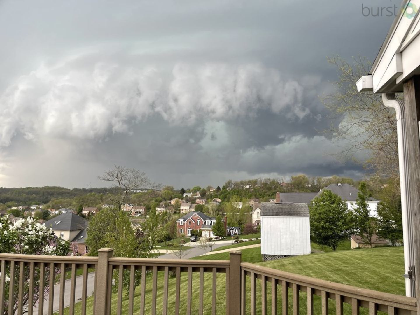
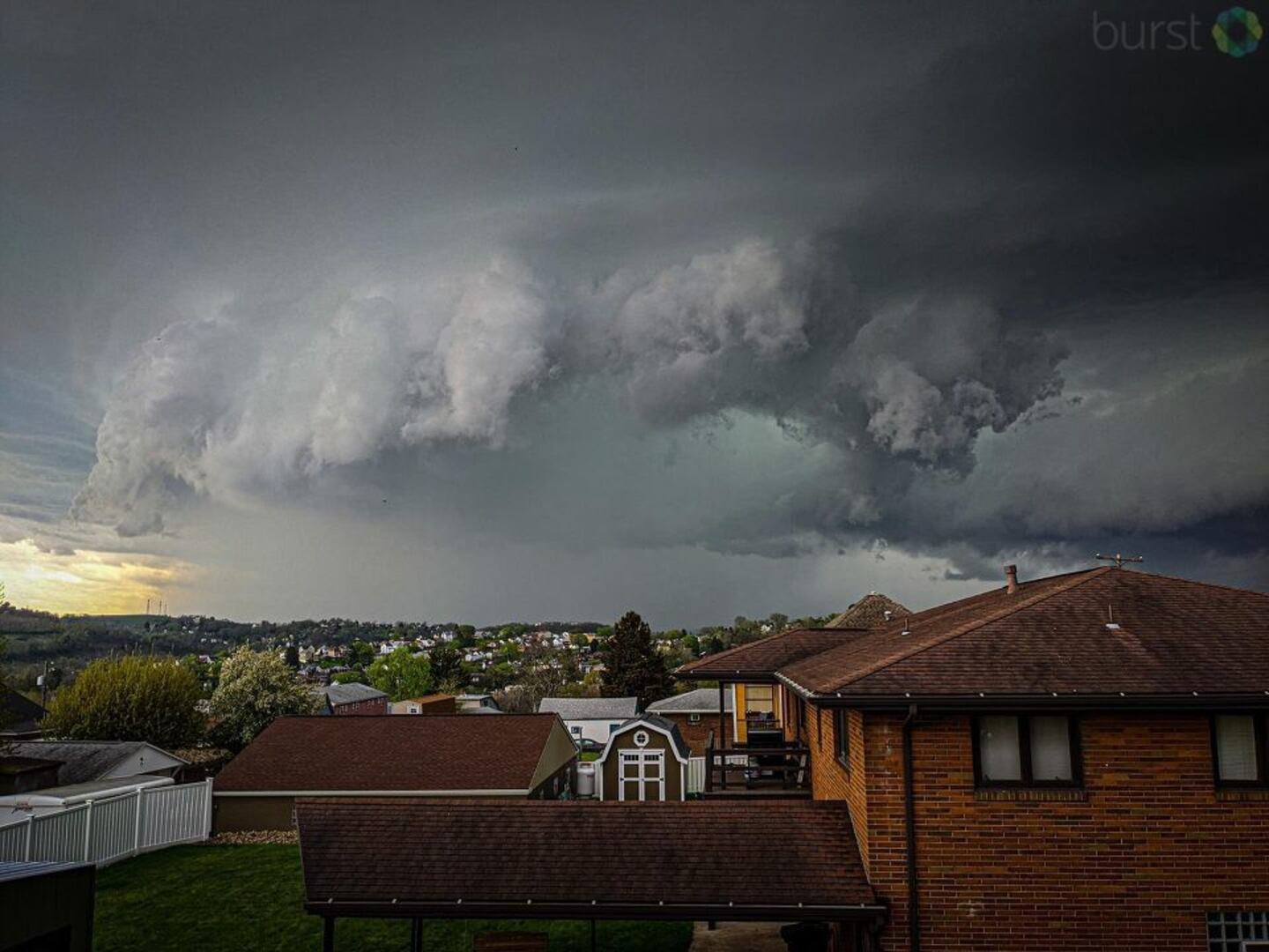
Photos submitted to Channel 11 by viewers reveal a large cloud forming above Canonsburg.
UPDATE: 8:05 p.m.
The National Weather Service issued an extension of the severe THUNDERSTORM WARNING for Fayette and Greene counties until 8:30 p.m.
UPDATE: 8:00 p.m.
A man is in critical condition after a tree fell on several cars and a gas station in Allegheny County during the region’s first round of storms.
Click here to for the full story.
UPDATE 7:47 p.m.
Power outages continue to grow in the midst of the severe weather peppering our area. Currently, there are 25,698 PennPower customers without power in Westmoreland County, 6,123 in Allegheny County and 9,104 without power in Washington County. Duquesne Light lists 5,209 customers in the area without power.
UPDATE 7:31 p.m.
A viewer in North Strabane shared these pictures with us from a massive tree uprooted during this evening’s severe weather @WPXI pic.twitter.com/RSnhfhNBuF
— Amy Hudak (@amy_hudak) May 3, 2022
UPDATE 7:22 p.m.
The sever THUNDERSTORM WARNING has been extended until 7:45 p.m. and now includes an extra portion of Beaver County.
Severe Thunderstorm Warning including East Liverpool OH, New Brighton PA and Toronto OH until 7:45 PM EDT pic.twitter.com/sjodA4x7x9
— NWS Pittsburgh (@NWSPittsburgh) May 3, 2022
UPDATE 6:58 p.m.
The severe THUNDERSTORM WARNING has been extended until 7:30 p.m. Other areas of Westmoreland County have been added to the warning.
Severe Thunderstorm Warning including Latrobe PA, Mount Pleasant PA and Loyalhanna PA until 7:30 PM EDT pic.twitter.com/Jm7GtGYg6N
— NWS Pittsburgh (@NWSPittsburgh) May 3, 2022
UPDATE 6:43 p.m.
The severe THUNDERSTORM WARNING has expanded to include Fayette and Westmoreland counties and has been extended to last until 7:15 p.m.
Severe Thunderstorm Warning including Connellsville PA, Mount Pleasant PA and Scottdale PA until 7:15 PM EDT pic.twitter.com/vJGaUzjhet
— NWS Pittsburgh (@NWSPittsburgh) May 3, 2022
UPDATE 6:26 p.m.
Penn Power shows over 7,500 customers are without power in Washington County and 1,500 customers without power in Allegheny County. Approximately 861 Duquesne Light customers are without power, according to their website.
UPDATE 6:13 p.m.
The severe THUNDERSTORM WARNING in Allegheny, Beaver and Washington Counties has been extended until 6:45 p.m.
Severe Thunderstorm Warning including Bethel Park PA, West Mifflin PA and Baldwin PA until 6:45 PM EDT pic.twitter.com/kd0EBHgaaS
— NWS Pittsburgh (@NWSPittsburgh) May 3, 2022
UPDATE 5:51 p.m.
A TORNADO WARNING has been issued for parts of Allegheny and Washington Counties.
The warning will be in effect until 6:15 p.m.
UPDATE 5:38 p.m.
A severe THUNDERSTORM WARNING has been issued for parts of Allegheny, Beaver and Washington Counties.
The warning will be in effect until 6:00 p.m. tonight.
Severe Thunderstorm Warning including Bethel Park PA, Weirton WV and Upper Saint Clair PA until 6:00 PM EDT pic.twitter.com/3zwgjVYfrW
— NWS Pittsburgh (@NWSPittsburgh) May 3, 2022
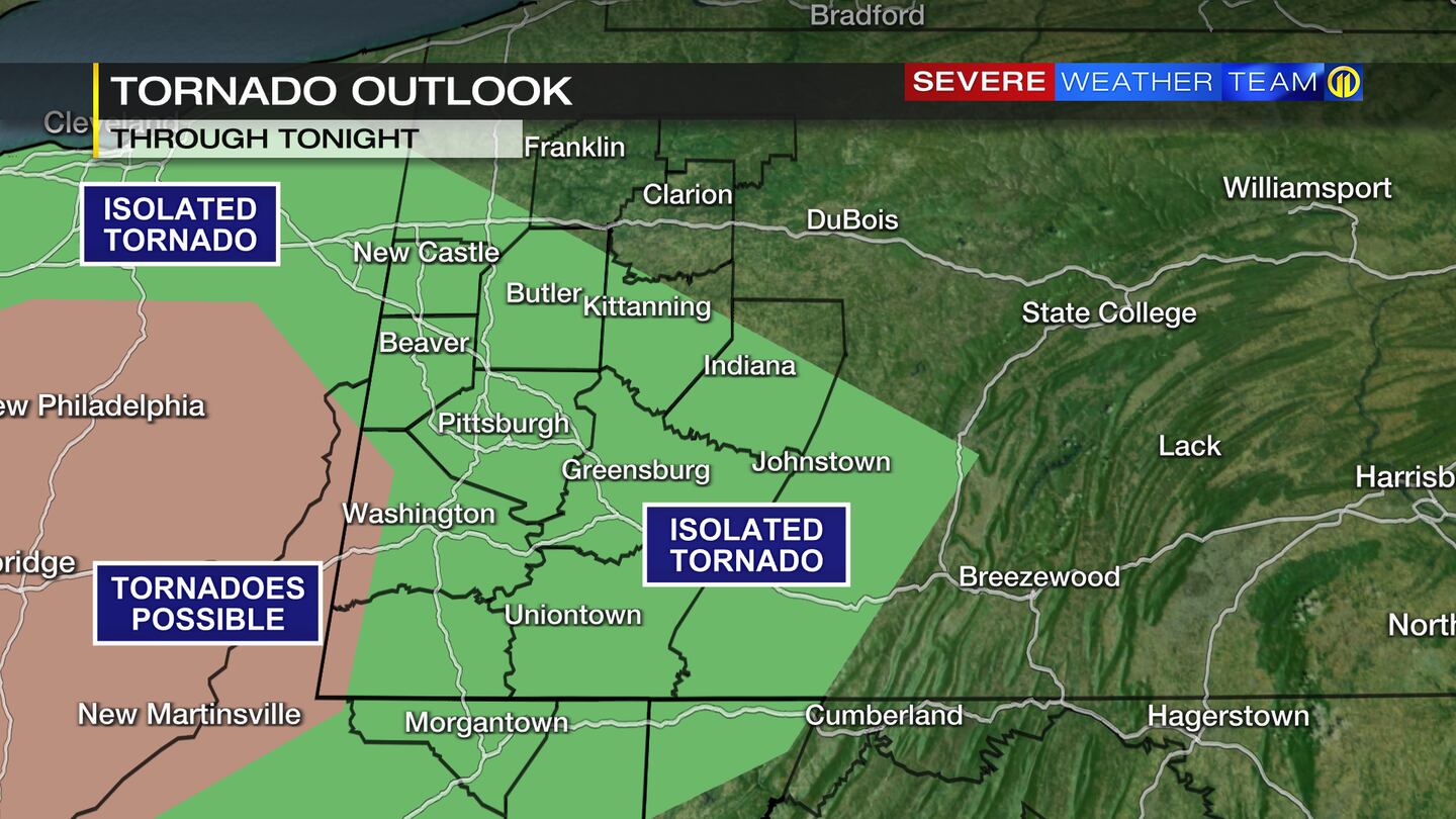
A TORNADO WATCH has been issued for Allegheny, Beaver, Washington, and Greene counties in PA until 9 p.m. Tuesday night.
Parts of eastern Ohio and northern West Virginia are also under the watch.
A tornado watch has been issued for parts of Indiana, Kentucky, Ohio, Pennsylvania and West Virginia until 9 PM EDT pic.twitter.com/6PbH7H1nl5
— NWS Pittsburgh (@NWSPittsburgh) May 3, 2022
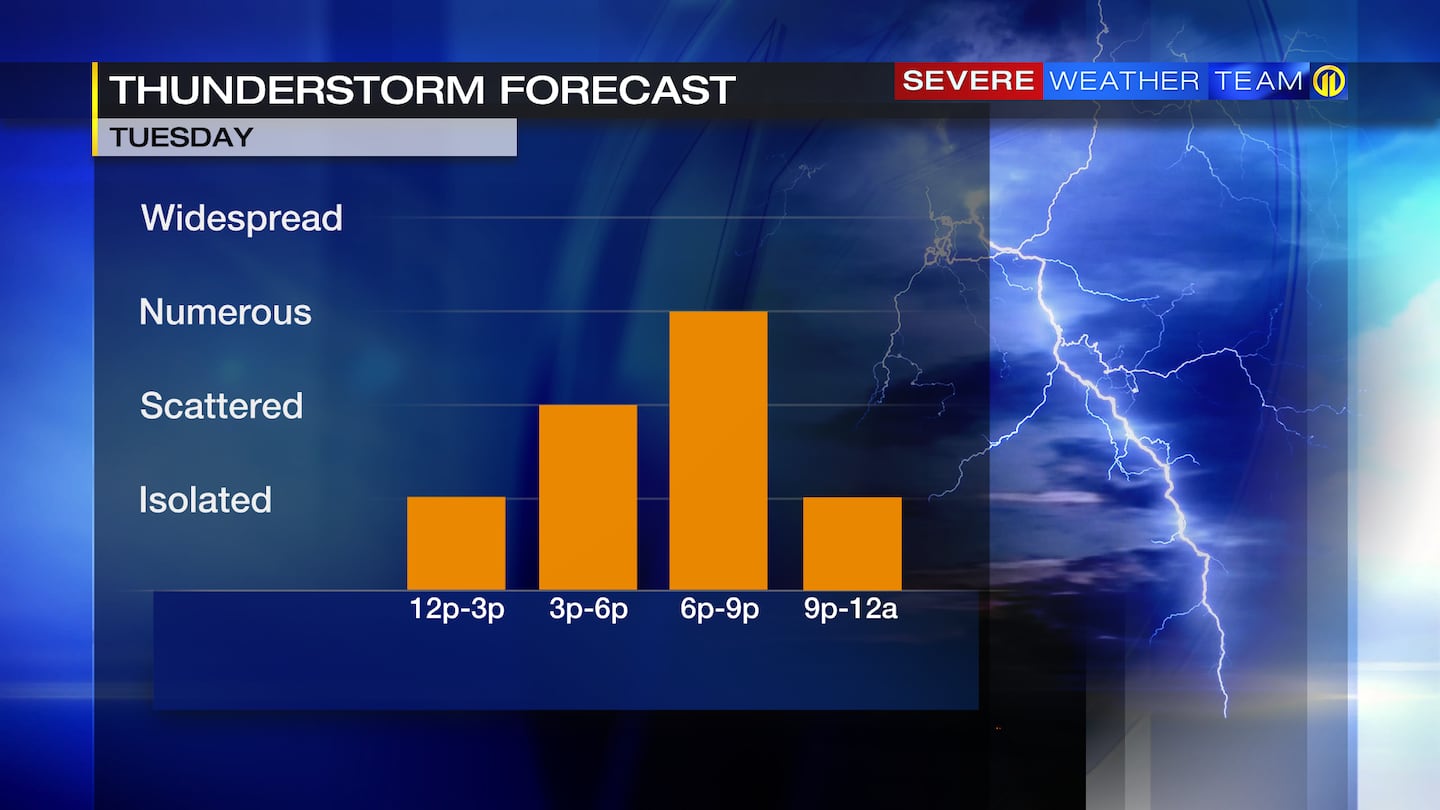
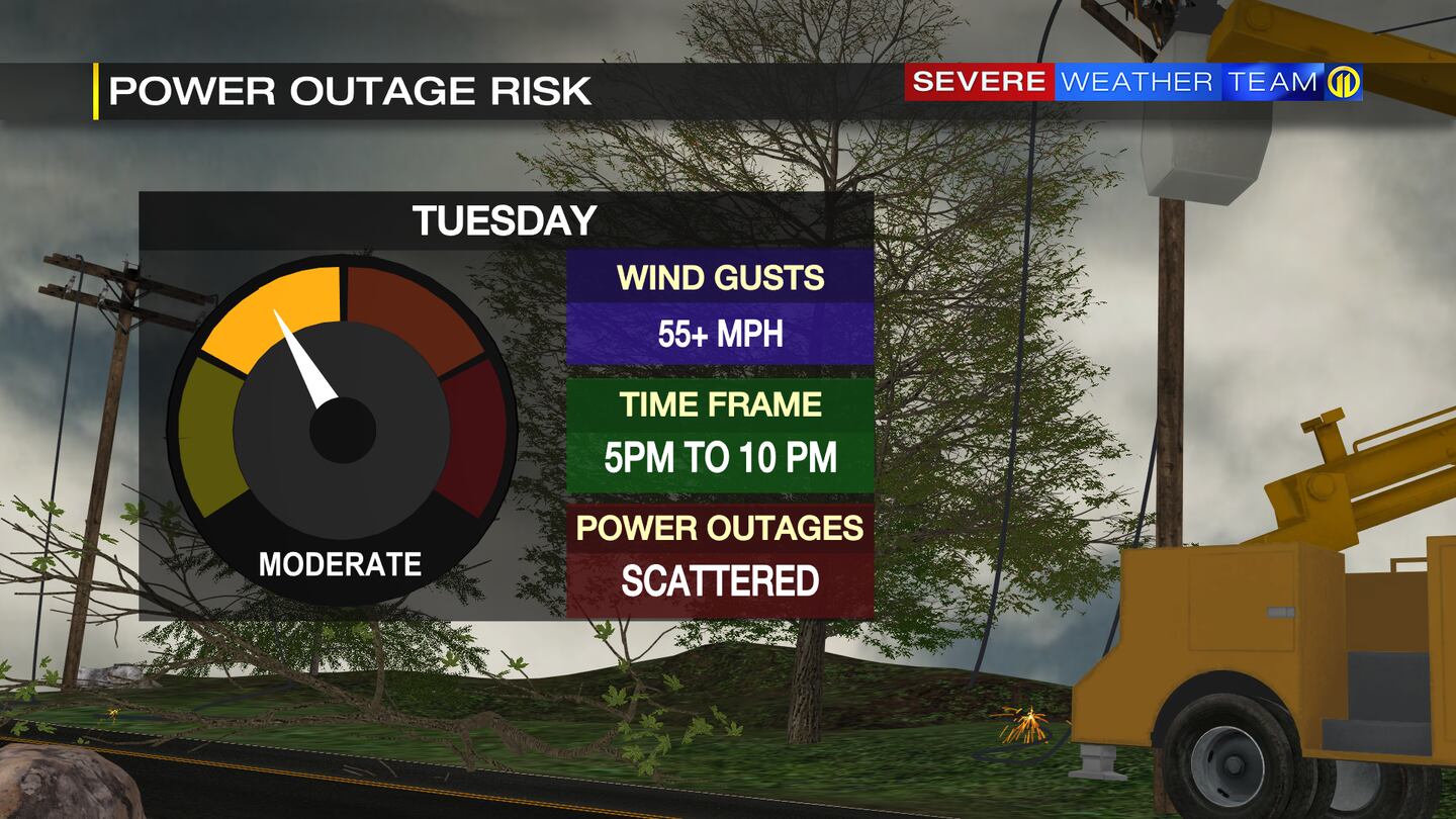
Torrential downpours, 55+ mph wind gusts and hail will all be possible with the thunderstorms. The strongest storms could produce a tornado or two as they cross into the area. The best chance for tornadic storms is from western Washington and Greene counties.
The risk for severe weather will ease after late this evening with spotty showers and an isolated storm left over for the late-night hours.
Stay weather alert when you can’t be in front of your TV with the Severe Weather Team 11 App. It’s a free, fast way to get alerts to severe weather, lightning strikes and updated forecasts from our team of meteorologists. Click here to download for FREE.
TRENDING NOW:

©2022 Cox Media Group
/cloudfront-us-east-1.images.arcpublishing.com/cmg/XCUXZC2XYZHCRGNNGKFEX6U3LQ.png)


