PITTSBURGH — Patchy fog could impact your plans late Wednesday and into Thursday.
LIVE weather updates NOW in our streaming apps and we'll have Severe Weather Team 11 coverage on the conditions on Channel 11 News starting at 4:30 a.m.
UPDATE 11 p.m. Wednesday: Visibility could drop as low as 1-2 miles at times, creating quickly changing travel conditions. A few icy spots will also be possible, especially in valleys where colder temperatures are slower to move out.
Highs will eventually climb into the 40s, melting snow and keeping roads wet. Sunshine returns Friday, but another system moves in for the weekend with more rain showers.
UPDATE 9 p.m. Wednesday: A Winter Weather Advisory has been extended until 1 a.m. for Armstrong, Clarion, Mercer, Indiana and Venango County.
If you want to receive BREAKING ALERTS, please download our WPXI News App. You can also follow WPXI on Facebook and Twitter.
UPDATE 6 p.m. Wednesday: A Winter Weather Advisory has been extended until 9 p.m. for Armstrong, Clarion, Indiana, Mercer and Venango counties.
UPDATE 4:05 p.m. Wednesday: Rain and fog will slow your travels tonight. Drains clogged by snow and ice could lead to ponding on area roads, so watch for quickly changing travel conditions.
PHOTOS: Snow slowing morning commute
UPDATE 1:50 p.m. Wednesday: The Mon Wharf will be closed starting Thursday and until further notice, the Public Parking Authority of Pittsburgh announced Wednesday. The decision was made after a flood advisory was issued for the Ohio River for Thursday and Friday.
Additional parking is available at the First Avenue Garage and Second Avenue Plaza.
UPDATE 1:13 p.m. Wednesday: The crash in the outbound lanes of the Parkway East has been moved to the right hand side.
Traffic is getting by in two lanes with delays.
TRAFFIC ALERT Earlier Accident Outbound Parkway East between the Greenfield Bridge in Squirrel Hill Tunnel has been moved to the right hand side. Traffic getting by now in two lanes with delays. #PittsburghTraffic #WPXIStorm #WPXI pic.twitter.com/WHTNvTgVE7
— WPXI Traffic (@WPXITraffic) February 20, 2019
UPDATE 12:55 p.m. Wednesday: PennDOT has lifted the speed limit restrictions on all roads except for I-79 north of Allegheny County, where the speed limit remains 45 mph.
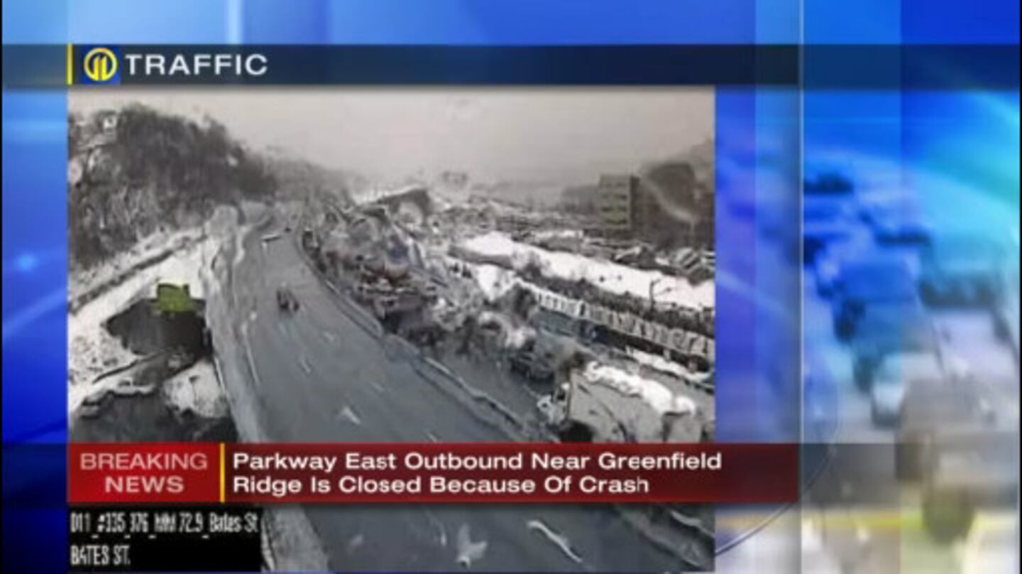
UPDATE 12:46 p.m. Wednesday: Parkway East outbound is closed near Greenfield Ridge due to a crash.
UPDATE: Crash on I-376 eastbound at Mile Post: 73.5. All lanes closed.
— 511PA Pittsburgh (@511PAPittsburgh) February 20, 2019
UPDATE 12:00 p.m. Wednesday: The winter weather advisory has expired for Southwestern Pennsylvania, but there are still many icy and snowy roads.
Winter Weather Advisory EXPIRED for southwestern PA. Still MANY icy and snowy roads.
— Scott Harbaugh (@WPXIScott) February 20, 2019
Live update on Channel 11 News at Noon. pic.twitter.com/PDT0OTohcg
If you want to receive BREAKING ALERTS, please download our WPXI News App. You can also follow WPXI on Facebook and Twitter.
UPDATE 11:13 a.m. Wednesday: Some areas saw around 5 inches of snow this morning.
Some of the bigger snowfall amounts this morning. How much do you have on the ground? pic.twitter.com/KfVvPFgM4P
— Scott Harbaugh (@WPXIScott) February 20, 2019
UPDATE 10:44 a.m. Wednesday: A Port Authority bus slid on ice and jackknifed into row houses in Pittsburgh's Uptown neighborhood.
#BREAKING: Port Authority bus going up Seneca slides on ice and jackknifes into row houses. @WPXI pic.twitter.com/7mbz6AjiFz
— Mike Holden (@WPXIMikeHolden) February 20, 2019
UPDATE 10:20 a.m. Wednesday: A salt truck overturned in Pittsburgh's Carrick neighborhood.
The driver was taken to a hospital.
BREAKING: Overturned salt truck in Pittsburgh on Steiner St and Cedar Cove near Baldwin. Driver taken to hospital. pic.twitter.com/jiKTCnHq9E
— Cara Sapida (@WPXICara) February 20, 2019
UPDATE 10:05 a.m. Wednesday: McKnight Road has reopened in both directions.
BREAKING NEWS UPDATE: McKnight Road is NOW OPEN in Both Directions at Babcock Blvd in Ross Twp. #PittsburghTraffic #wpxistorm #wpxi pic.twitter.com/2kCUY9XvJe
— WPXI Traffic (@WPXITraffic) February 20, 2019
UPDATE 10:25 a.m. Wednesday: Meteorologist Scott Harbaugh said there will be some area that will see more than 4 inches by the time everything is done falling.
TOTAL snowfall by the time all is said and done. YES, there will be a spot or two that get a touch more than 4".
— Scott Harbaugh (@WPXIScott) February 20, 2019
Updates ---> https://t.co/3lNA1g4kFS pic.twitter.com/AzHkRIbtmK
UPDATE 9:45 a.m. Wednesday: McKnight Road inbound has reopened at Babcock Boulevard.
The outbound lanes remain closed.
BREAKING NEWS UPDATE: McKnight Road Southbound / Inbound is OPEN at Babcock Blvd But Remains CLOSED OUTBOUND. #PittsburghTraffic #wpxistorm #wpxi pic.twitter.com/pIwdkbjW6w
— WPXI Traffic (@WPXITraffic) February 20, 2019
UPDATE 9:45 a.m. Wednesday: Snow, sleet and freezing rain will ease up a bit and will allow crews an opportunity to start to catch up.
Snow, sleet, freezing rain will ease up a bit allowing crews an opportunity to start to catch up.
— Scott Harbaugh (@WPXIScott) February 20, 2019
Updates at 25/55 past the hour on @WPXI pic.twitter.com/NseHGQoIuz
UPDATE 9:36 a.m. Wednesday: All on-street bus routes are now delayed about an hour due to traffic and weather conditions, according to a tweet from the Port Authority.
All on-street bus routes are delayed about an hour due to traffic/road conditions. Busway routes are only delayed slightly. Bus routes Y46 and Y49 outbound are blocked at 51 at Brownsville Rd due to a jackknifed tractor trailer. Extended delays expected on those routes
— Port Authority PGH (@PGHtransit) February 20, 2019
Bus routes Y46 and Y49 outbound are blocked at 51 at Brownsville Road due to a jackknifed tractor-trailer.
UPDATE 9:21 a.m. Wednesday: According to a tweet from Pittsburgh International Airport, there are about 20 flights canceled to D.C., Philadelphia, Boston and the East Coast as of 8 a.m.
Crews have been busy this morning with snow and preparing for freezing rain this afternoon. As of 8 am, monitors showing about 20 flight cancellations to DC, Philly, Boston, and East Coast. PIT alternating between 2-3 open runways. pic.twitter.com/O6ucEvq3x4
— Pittsburgh International Airport (@PITairport) February 20, 2019
UPDATE 9:04 a.m. Wednesday: Allegheny County tweeted that their crews will be out until at least 9 p.m. salting and plowing
As snow continues to fall, we’re urging drivers to be extra cautious this morning. We have 27 trucks out salting/plowing county-owned roads. We’ve gone over each of them at least once, some of twice, but because of the intensity of the snow, they quickly get covered again.
— Allegheny County (@Allegheny_Co) February 20, 2019
UPDATE 8:55 a.m. Wednesday: McKnight Road is closed in both directions in the area of lower Babcock Boulevard in Ross Township.
Police are redirecting traffic until the road can be treated.
BREAKING NEWS: McKnight Road is CLOSED in Both Directions in the area of Lower Babcock Blvd in Ross Twp. Police Re-Directing Traffic Until the Road Can Be Treated. #PittsburghTraffic #wpxistorm #wpxi pic.twitter.com/FB2I5auzn5
— WPXI Traffic (@WPXITraffic) February 20, 2019
UPDATE 8:30 a.m. Wednesday: The I-279 HOV lanes are closed until further notice due to weather conditions, according to PennDOT.
UPDATE 8:45 a.m. Wednesday: Pittsburgh Public Schools released a statement on social media after they did not cancel classes today:
The Pittsburgh Public Schools did not call a delay as students and buses had already begun the morning commute before...
Posted by Pittsburgh Public Schools on Wednesday, February 20, 2019
UPDATE 8:41 a.m. Wednesday: Meteorologist Scott Harbaugh says the mix line is heading north fast. There is now freezing rain in Washington.
Mix line heading north fast. Now freezing rain in Washington. This will create an even icier situation.
— Scott Harbaugh (@WPXIScott) February 20, 2019
Live coverage now on @WPXI pic.twitter.com/tnc5EOoPG0
UPDATE 8:39 a.m. Wednesday: Inbound rive times are close to or over an hour across the area.
As of 8:35am - Here's a Look at Your Inbound Drive Times. Route 28 Delays Begin Before Harmar / PA Turnpike. #PittsburghTraffic #wpxistorm #wpxi pic.twitter.com/nYNcMjMu8D
— WPXI Traffic (@WPXITraffic) February 20, 2019
UPDATE 8:30 a.m. Wednesday: A wintry mix is falling in Washington. What started as snow changed to sleet and then to freezing rain.
We’ve made the transition to a wintry mix here in Washington, PA, went from heavy snow to sleet and now freezing rain. 😝 #wpxistorm #PAwx pic.twitter.com/WDxm2EQklL
— Danielle Dozier WPXI (@DanielleDozier) February 20, 2019
UPDATE 7:30 a.m. Wednesday: Road conditions are deteriorating as snow picks up and more cars head out for the morning commute.
Snow falling fast in Squirrel Hill right now. #wpxistorm pic.twitter.com/DgH2HAxseN
— Aaron Martin (@WPXIAaronMartin) February 20, 2019
Crawling along Banksville. 6 tenths of a mile took 8 minute. And now we have a delay..... @WPXI @WPXITraffic pic.twitter.com/haCxrXJsei
— Mike Holden (@WPXIMikeHolden) February 20, 2019
UPDATE 6:35 a.m. Wednesday: Snow continues to push north, with a wintry mix south of Interstate 70.
Snow continues pushing north. Mix south of I-70.
— Scott Harbaugh (@WPXIScott) February 20, 2019
MANY snow-covered roads. Live Team 11 coverage continues now on Channel 11 Morning News. pic.twitter.com/aqKs2bxSyf
UPDATE 6:15 a.m. Wednesday: Snow has reached Pittsburgh as it continues to spread north.
Here’s a better view of the snow we’re experiencing on the North Side of Pittsburgh. @WPXI pic.twitter.com/d7YC7dNLXz
— WPXIJennifer Tomazic (@JenniferTomazic) February 20, 2019
UPDATE 5:40 a.m. Wednesday: Sleet is overtaking areas south of Interstate 70.
Sleet overtaking many areas south of I-70. We have you covered with crews all over the place LIVE now on Channel 11 Morning News. pic.twitter.com/jdFJjIzt36
— Scott Harbaugh (@WPXIScott) February 20, 2019
UPDATE 5:30 a.m. Wednesday: The worst travel conditions because of the winter storm are expected between 7 a.m. and 11 a.m.
Worst of the day for travel will be 7am to 11am.
— Scott Harbaugh (@WPXIScott) February 20, 2019
Live updates now on Channel 11 Morning News. pic.twitter.com/j4Be7p78OZ
UPDATE 4:45 a.m. Wednesday: Snow has started falling in Washington County before it overspreads the entire area later this morning.
Channel 11 Meteorologist @DanielleDozier has snow in Amwell township.
— Scott Harbaugh (@WPXIScott) February 20, 2019
Live Team 11 coverage now on Channel 11 Morning News. pic.twitter.com/OPz4fadzGu
ORIGINAL STORY: Moderate to heavy snow is possible during the morning hours. Expect delays and cancellations to build heading into the day.
A Winter Weather Advisory will be in effect Wednesday for much of the area, and a Winter Storm Warning for the mountains.
Winter Weather Advisories and Winter Storm Warnings up!
— Scott Harbaugh (@WPXIScott) February 20, 2019
Tracking snow that will snarl the morning commute on Channel 11 Morning News from 4AM to 7AM. pic.twitter.com/CnJlDumtx7
Snow will start before sunrise south of Pittsburgh, then move north through the rest of the area during the morning.
Roads will quickly become snow covered, and snowfall rates could be as heavy as 1 inch per hour at times. The combination of steady snow and rush hour traffic will lead to major delays as road crews try to keep roads passable.
STORM TRACKER: Hour-by-hour look at snow, wintry mix for Wednesday
Several inches of snow will fall, then a mixture of sleet and freezing rain will move into the area by mid-morning. A layer of snow, then a layer of ice on top will make travel hazardous through at least noon for many locations.
If you want to receive BREAKING ALERTS, please download our WPXI News App. You can also follow WPXI on Facebook and Twitter.
Temperatures will climb above freezing by the afternoon, with the wintry mix changing to rain.
Rain could be steady at times, and drains clogged by snow and ice could lead to ponding on roads.
This is a tricky storm as warm air moves in from the south and snow changes to freezing rain, sleet and rain. Check back for updates from Severe Weather Team 11.
Cox Media Group
/cloudfront-us-east-1.images.arcpublishing.com/cmg/XCUXZC2XYZHCRGNNGKFEX6U3LQ.png)


