PITTSBURGH — The remnants of Ida moved into western Pennsylvania, dumping rain across the area and causing flooding. That rain will continue throughout the day Wednesday, following showers and storms that already created problems in parts of the area on Tuesday.
- LIVE INTERACTIVE RADAR
- SCHOOL CLOSINGS/DELAYS
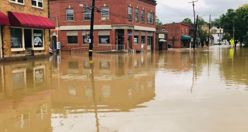
- PHOTOS: Heavy rain from the remnants of Ida is causing flooding across the Pittsburgh area
UPDATE 11 p.m.: People living along the Mon and Yough rivers are preparing tonight ahead of expected flooding Thursday morning.
The National Weather Service said those rivers could crest in areas above what we saw from Hurricane Ivan. Homes and businesses could be inundated by the flood waters.
UPDATE 9:30 p.m.: A daycare owner told Channel 11 she’s thankful there were no children inside as the flood waters quickly rose Wednesday morning.
>>>READ MORE: Daycare owner thankful no kids inside as rushing water flooded facility
UPDATE 5:17 p.m.: The U.S. Army Corps of Engineers Pittsburgh District declared a state of emergency due to flooding conditions impacting the Monongahela River and its tributaries, Sept. 1, 2021.
This emergency declaration authorizes the U.S. Army Corps of Engineers to undertake support emergency response activities caused by the natural disaster.
The Pittsburgh District may provide support to local communities in need, and repair or rehabilitate flood control projects damaged during the state of emergency.
“If communities request support, we can provide assistance under this declaration,” said Al Coglio, the chief of emergency management for the Pittsburgh District.
UPDATE 4:03 p.m.: Heavy rain ripped through parts of Oakdale, devastating one of the main roads. Business owners are dealing with damage from water and debris.
UPDATE 2:50 p.m.: Soaking rain from Ida will move out by evening, decreasing the Flash Flood threat for most areas.
River levels will continue to rise, especially along the Monongahela, Youghiogheny and Ohio, so take action now if you live an area impacted by river flooding.
Cooler, less humid air will settle into the area the next few days, with no rain in the forecast until Sunday.
UPDATE 2:32 p.m.: Students are being dismissed early all over our area today due to rising waters.
⚠️Several roadways in our region have flooded and some school districts have dismissed students early today. Please, if you must travel today, leave early, be EXTRA careful and avoid driving on flooded roadways. Thank you!
— Troopers Steve Limani & Cliff Greenfield (@PSPTroopAPIO) September 1, 2021
UPDATE 1:48 p.m.: Flooding continues to be an issue in Oakdale.
Flooding in Oakdale. @WPXI #HurricaneIda #flooding pic.twitter.com/d5kYTYrQZn
— Michele Newell (@micheleWPXI) September 1, 2021
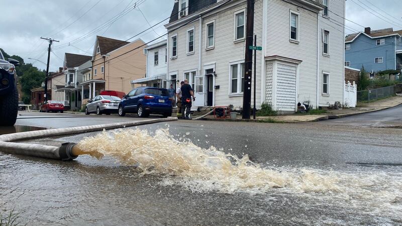
UPDATE 1:27 p.m.: Water is being pumped out of homes and businesses in Millvale.
UPDATE 1:00 p.m.: Governor Tom Wolf was joined by the Pennsylvania Emergency Management Agency (PEMA), Department of Transportation (PennDOT), and the Pennsylvania State Police (PSP) to provide an update on state agency response to remnants of Ida, which is currently impacting the commonwealth with heavy rain and significant flooding.
“This is an extremely dangerous storm that is impacting the entire state. As we continue to monitor the conditions, I ask everyone to please stay home if you’re able,” Gov. Wolf said. “If you must travel, please monitor the latest road conditions and weather updates. Please, I urge everyone to take this storm seriously and stay safe.”
“We have dispatched water rescue teams from parts of the state that will see less flooding and moved them to areas where we expect more significant impacts from the rain and flooding,” said PEMA Director Randy Padfield. “We now need people to stay off the roads unless travel is necessary. If you must travel, do so safely and be aware that conditions can change quickly.”
The Commonwealth Response Coordination Center (CRCC) began 24-hour operations at 8:00 AM Wednesday with in-person or virtual staffing from the following agencies: departments of Environmental Protection, General Services, Health, Military and Veterans Affairs, Human Services and Transportation; Office of the Attorney General; Pennsylvania State Police; Fish and Boat Commission; Public Utility Commission; Turnpike Commission; American Red Cross; and Civil Air Patrol.
“Our crews have been preparing for days by clearing out debris around drainage inlets and under bridges while readying equipment,” Acting PennDOT Executive Deputy Secretary Melissa Batula said. “With the forecast amount of rain, we remind the public to not drive on roads that are covered with water because even shallow, swiftly flowing water can wash a car from a roadway.”
Motorists should watch for ponding on roadways and flooding in poor drainage areas while traveling.
The Pennsylvania Department of Transportation (PennDOT) warns motorists not to drive across roads covered with water because even shallow, swiftly flowing water can wash a car from a roadway. Also, the roadbed may not be intact under the water. Never drive around barricades or signs on closed roads – Turn Around, Don’t Drown.
.@GovernorTomWolf was joined by @PEMAHQ, @PennDOTNews, and @PAStatePolice to provide an update on state agencies' response to remnants of Ida, which is currently impacting the commonwealth with heavy rain and significant flooding. https://t.co/EdKSoR5qow
— Office of the Governor (@GovernorsOffice) September 1, 2021
Anyone planning to travel should closely monitor weather conditions along travel routes. Motorists can check conditions on more than 40,000 roadway miles, including color-coded winter conditions on 2,900 miles, by visiting www.511PA.com. 511PA, which is free and available 24 hours a day, provides traffic delay warnings, weather forecasts, traffic speed information and access to more than 1,000 traffic cameras.
UPDATE 12:42 p.m.: The President and Vice President of the Board in Scott Township have declared a state of emergency due to flooding and heavy rain in the area.
The President and Vice President of the Board in Scott Township have declared a state of emergency.
— Allegheny County (@Allegheny_Co) September 1, 2021
The PA Department of Conservation & Natural Resources is closing several PA State Parks campsites today and Thursday as the remnants of Tropical Depression Ida are expected to bring 4 to 6 inches of rain to a large portion of PA, with some areas expected to see 8 inches or more.
DCNR is closing several #PAStateParks & #PAStateForests campsites today and Thursday as the remnants of Tropical Depression Ida are expected to bring 4 to 6 inches of rain to a large portion of PA, with some areas expected to see 8 inches or more. More ➡️ https://t.co/q2DNZ3mQJy pic.twitter.com/Ai1Bmktd8p
— PA Department of Conservation & Natural Resources (@DCNRnews) September 1, 2021
UPDATE 12:23 p.m.: Crews spent the morning performing water rescues. 260 boat rescued 41 passengers from the school bus and 10 more from homes that took on water rapidly, according to a tweet from the Cherry Hill Fire Department.
Crews have been spending the morning performing water rescues. 260 boat rescued 41 passengers from the school bus and 10 more from homes that took on water rapidly. pic.twitter.com/ZDsfipEKAg
— Cherry City Fire (@CherryCityFire) September 1, 2021
UPDATE 12:10 p.m.: Gov. Tom Wolf was joined by the Pennsylvania Emergency Management Agency, the Pennsylvania Department of Transportation and the Pennsylvania State Police to give an update on Wednesday’s rain and flooding caused by the remnants of Ida.
“This is an extremely dangerous storm that is impacting the entire state. As we continue to monitor the conditions, I ask everyone to please stay home if you’re able,” Wolf said. “If you must travel, please monitor the latest road conditions and weather updates. Please, I urge everyone to take this storm seriously and stay safe.”
Water rescue teams have been dispatched to appropriate areas of the state.
“We have dispatched water rescue teams from parts of the state that will see less flooding and moved them to areas where we expect more significant impacts from the rain and flooding,” said PEMA Director Randy Padfield. “We now need people to stay off the roads unless travel is necessary. If you must travel, do so safely and be aware that conditions can change quickly.”
Acting PennDOT Executive Deputy Secretary Melissa Batula said crews had been preparing for days by clearing out debris around drainage inlets and under bridges.
Ahead of Ida’s arrival in Pennsylvania, Wolf signed a proclamation of disaster emergency.
UPDATE 11:55 a.m.: Route 51, which was closed between Bausman and Whited streets, has reopened. Floodwaters have receded.
UPDATE: Water has receded. Rt 51 between Bausman and Whited has reopened @WPXI @WPXITraffic pic.twitter.com/VtNFwJUFfH
— Alyssa Raymond (@AlyssaRaymond) September 1, 2021
UPDATE 11:50 a.m.: New Flood Warnings have been issued for the following areas:
- Monongahela River near Charleroi (until Thursday at 3:50 p.m.)
- Monongahela River near Elizabeth (until Thursday at 8 p.m.)
- Conemaugh River at Seward (until Friday at 12:20 a.m.)
- Youghiogheny River at Connellsville (until Friday at 2:30 a.m.)
- Youghiogheny River at Sutersville (until Friday at 3:08 a.m.)
UPDATE 10:25 a.m.: As rushing water in Pine Creek rises, crews are working to get debris out of the way.
UPDATE 10:15 a.m.: Yards of several homes on Kay Street in Shaler Township flooded.
Several homes are dealing with flooding on Kay St. in Shaler Township pic.twitter.com/FYfnCwaPXf
— Jessica Faith (@JessicaWPXI) September 1, 2021
UPDATE 10 a.m.: Because of flooding in the Pine Creek area of Etna, people are being asked to evacuate if they live in the floodplain or anywhere near the creek. For those without a place to go, the following locations are available: Emmanuel Lutheran Church on Grant Avenue and the Shaler School District Administrative Building on Mt. Royal Boulevard.
UPDATE ON FLOODING: The Emergency Management Agency is notifying you that flooding as begun to occur in the Pine Creek...
Posted by Borough of Etna on Wednesday, September 1, 2021
UPDATE 9:30 a.m.: A Flash Flood Warning has been extended until 3:30 p.m. for parts of Allegheny, Armstrong, Fayette, Greene, Washington, Westmoreland and Indiana counties.
UPDATE 8:55 a.m.: Valley High School in New Kensington is being evacuated, according to Brian Rittmeyer, a reporter for Channel 11′s news exchange partners at TribLIVE.
BREAKING: Valley High School in New Kensington is being evacuated. pic.twitter.com/sb7NLhYygC
— Brian Rittmeyer (@BCRittmeyer) September 1, 2021
UPDATE 8:30 a.m.: At least three cars got stuck in floodwaters on Route 51. A driver of one of the cars said the water quickly rose from a couple inches to a couple feet. She said her car felt like a boat.
At least 3 cars got stuck in this section of 51 that flooded. This is between Bausman and Whited. Driver of one of these cars says the water came up so quickly. Went from a couple inches to a couple feet. She says her car felt like a boat. @WPXI
— Alyssa Raymond (@AlyssaRaymond) September 1, 2021
Radar - https://t.co/YfikrdcK55 pic.twitter.com/03VCcHdwj1
UPDATE 8:25 a.m.: A disaster emergency has been declared in Bridgeville by Mayor Copeland.
Bridgeville: Mayor Copeland has declared a disaster emergency in the borough
— Allegheny County (@Allegheny_Co) September 1, 2021
UPDATE 7:55 a.m.: Evacuations are underway in Bridgeville. The Bridgeville Volunteer Fire Department is urging people on Baldwin Street and McLaughlin Run to evacuate. The fire department and Bethany Church are open for shelter.
Bridgeville: Swift Water team responding to assist with evacuations
— Allegheny County (@Allegheny_Co) September 1, 2021
UPDATE 7:45 a.m.: Route 50 in Scott Township is flooded.
#WPXIStorm - Rt50/Washington Ave close due to #flooding at Boden in Scott Twp. #WPXI #PGH #PITTSBURGH @WPXITraffic @WPXIScott pic.twitter.com/qfYJ4r2htn
— Tony Ruffolo (@WPXITonyRuffolo) September 1, 2021
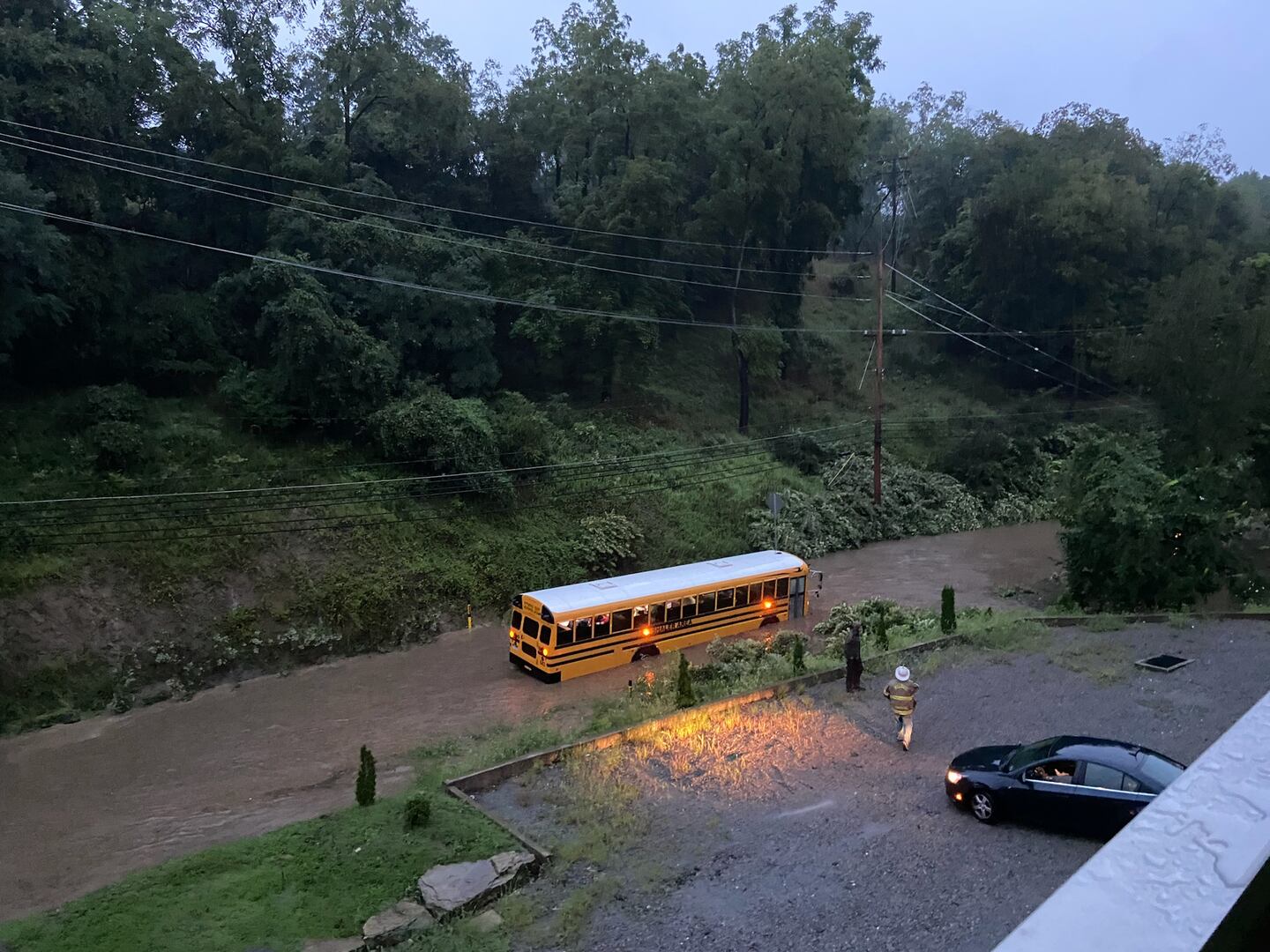
UPDATE 7:35 a.m.: All students who were on a school bus that got stuck in floodwaters on Seavey Road in Shaler Township were evacuated to a safe area, police said.
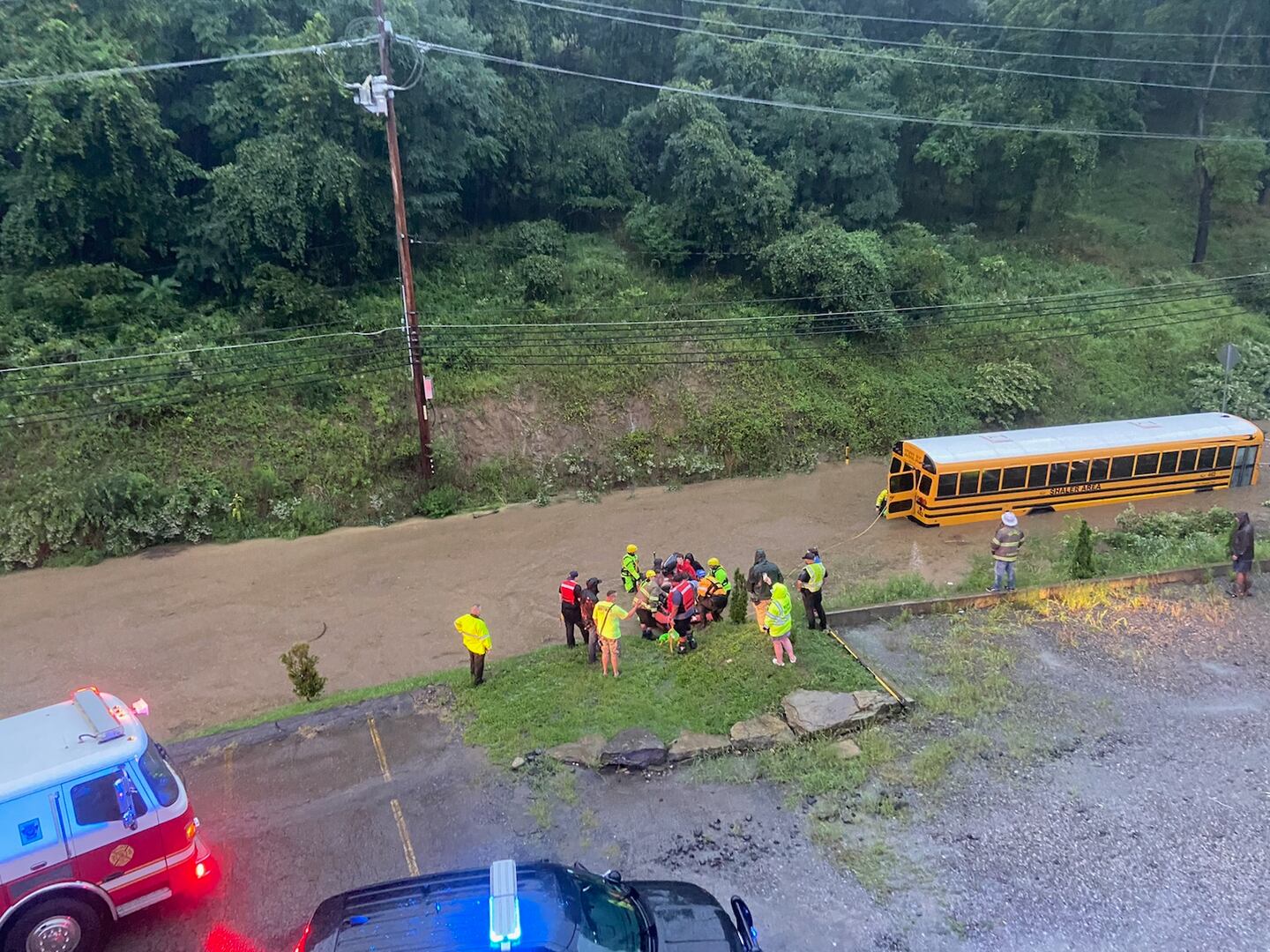
Update 07:20 am - All students who were on the school bus were evacuated to a safe area. Road Closure: Seavey Rd is closed between Elbe Dr and Soose Rd due to roadway Flooding. Avoid this area.
Posted by Shaler Township Police Department on Wednesday, September 1, 2021
UPDATE 7:30 a.m.: The flood gates on Washington Boulevard have been activated. There is also flooding on Route 51.
There are multiple areas of flooding along Route 51 / Saw Mill Run.
— Pgh Public Safety (@PghPublicSafety) September 1, 2021
Please avoid driving on this road unless it is an emergency. https://t.co/MRltBVL3zR
UPDATE 7:23 a.m.: Pittsburgh Public Safety is reporting there are several water rescues happening right now throughout the city.
URGENT ALERT:
— Pgh Public Safety (@PghPublicSafety) September 1, 2021
The heavy rainfall has resulted in flooding around the city.
Numerous water rescues are being conducted and motorists need to heed all flood barriers and avoid driving through rising waters.
Route 51 between Bausman and Whited is flooded.
Please use caution. pic.twitter.com/m7IjxFsyqx
UPDATE 7:15 a.m.: Valley Brook Road in in Peters Township is flooded as a creek overflows its banks.
#WPXIStorm - creek overflowing its banks onto Valley Brook in McMurray. #WPXI #PGH #Pittsburgh @WPXIScott @WPXITraffic #VIDEO pic.twitter.com/C3TNoZEs3Q
— Tony Ruffolo (@WPXITonyRuffolo) September 1, 2021
UPDATE 7:05 a.m.: A school bus with students on board is stuck in floodwaters on Seavey Road in Shaler Township.
UPDATE 6:25 a.m.: A Flash Flood Warning is in effect until 12:15 p.m. for parts of Allegheny, Armstrong, Butler, Beaver, Washington, Westmoreland and Indiana counties.
FLASH FLOOD WARNING: For portions of Allegheny, Washington, Westmoreland, Armstrong, Butler, Indiana, and Beaver Counties until 12:15 PM. pic.twitter.com/Xhvf5W8zGj
— Jessica Faith (@JessicaWPXI) September 1, 2021
UPDATE 6:20 a.m.: Reports of road closures are coming in from across the area. Among them are Baldwin Street in Bridgeville, Baldwin Road in Hays, Piney Fork Road in South Park and Little Pine Creek Road in Shaler.
NUMEROUS roads closed due to flooding throughout the area. We’re also keeping an eye on some roads impacted by downed trees and wires. Here are 4 roads that you want to avoid in Bridgeville, Hayes, South Park and Shaler. #PittsburghTraffic #WPXI pic.twitter.com/urmPnqN1yg
— WPXI Traffic (@WPXITraffic) September 1, 2021
UPDATE 5:45 a.m.: Power outages are being reported in parts of the area, some in locations where downed trees or wires have been reported.
Here are links to the latest outage maps from Duquesne Light and West Penn Power:
UPDATE 5:30 a.m.: As the rain comes down in Elizabeth Township, rescue crews are on standby.
The fire department has five boats ready to go at a moment’s notice if flooding becomes an issue.
Officials are urging homeowners and business owners to pay attention and be prepared if they’re near a stream, creek or river that could rise.
UPDATE 5:25 a.m.: A flood advisory is in effect for parts of Allegheny, Beaver, Washington and Westmoreland counties until 7 a.m.
Flood Advisory. First one issued today. Many more to come. Live Ida coverage now on Channel 11 Morning News.
— Scott Harbaugh (@WPXIScott) September 1, 2021
Watch live: https://t.co/mmXOytnrtc pic.twitter.com/77Ax9uxRKA
UPDATE 4:30 a.m.: Ida is dumping widespread rain on our area, setting up the potential for flash flooding Wednesday.
TUESDAY UPDATES
UPDATE 11:05 p.m.: The growing concern Tuesday afternoon was that the worst of the rain was still to come, despite the flooding inundating roads, yards and homes. All of that water will continue to flow into the larger waterways, including the Mon River.
“Everybody needs to be prepared for this. It’s going to be bad in the morning,” said Elizabeth Volunteer Fire Chief Chad Rager.
Five boats were on standby at Elizabeth’s fire department and ready to help rescue anyone at a moment’s notice.
UPDATE 11 p.m.: Another area pummeled by rain Tuesday was Peters Township. With more rain on the way, it’s causing concern as creeks and streams were already running high or had already spilled over the banks.
Railroad Street in Peters was flooded because the creek nearby overflowed.
“I live about a quarter mile up the road and it’s flooded at least half of that way,” said Millie Podnar.
UPDATE 10:53 p.m.: Several school districts are closed or delayed for Wednesday.
- Avella: Closed, Flexible Instruction Day
- Burgettstown: Closed, Flexible Instruction Day
- Fort Cherry: Closed
- Uniontown: 2 hour delay
UPDATE 9:15 p.m.: Here’s your updated forecast for late Tuesday night into Wednesday.
Rain will slow your morning commute Wednesday, and some areas could see more flooding. A band of moderate to heavy rain is expected, especially across parts of Allegheny, Washington, Westmoreland and Fayette counties.
Quick rises on streams and creeks could trigger more Flash Flood Warnings, so be prepared to change your travel plans is roads are closed. The steadiest rain should taper to more showers by noon across Allegheny County, but moderate rain will still be possible for Westmoreland until early afternoon.
Some areas have already picked up enough rain to cause flooding, and additional rainfall of 1″ to 2″ or more will cause even more problems.
River flooding is expected to begin along the Mon River by late Wednesday and continue into Thursday, and flooding on the Ohio River at the Point is expected by Thursday afternoon. The fountain at the Point could be under half a foot of water by Thursday.
UPDATE 9 p.m.: Governor Tom Wolf signed a disaster emergency proclamation ahead of significant rainfall and expected widespread flooding from the remnants of Ida.
“This dangerous storm continues to have devastating impacts across the South and as it heads toward Pennsylvania, we are expecting significant rainfall across the state. This proclamation will allow for our emergency preparedness teams to provide any support needed throughout the storm and its aftermath,” Gov. Wolf said. “I urge Pennsylvanians to monitor local weather and traffic conditions before making any plans and prepare for potential flooding.”
UPDATE 7:03 p.m.: Channel 11′s Amy Hudak says you can hear the roar of Peters Creek as the fast flowing water is flooding areas beyond its banks.
You can hear the force of Peter’s Creek as it flows through South Park @WPXI pic.twitter.com/yorofoeEnk
— Amy Hudak (@amy_hudak) August 31, 2021
UPDATE 7 p.m.: Channel 11′s Amy Hudak reports there is widespread flooding along Piney Fork, a creek, in South Park.
A section of Piney Creek Road in South Park is covered in water (this is as far as we could safely get). The creek that runs along the road is flowing fast @WPXI pic.twitter.com/QnlPqa88vC
— Amy Hudak (@amy_hudak) August 31, 2021
Additionally, the Finleyville Volunteer Fire Department reports there are multiple flooded roads in Union and Nottingham townships. Rescue crews have also been helping people out of flooded homes.
UPDATE 6:41 p.m.: The National Weather Service has expanded the Flash Flood Watch to now include areas further to the north of Pittsburgh. This also means there could be locally higher amounts of rainfall.
The Flash Flood Watch for tonight through early Thurs has been expanded farther into eastern Ohio and north of Pittsburgh. Our latest rainfall forecast for tonight through Wednesday night nudges higher amounts slightly northwards from previous forecasts. pic.twitter.com/ZDhfqIJPvS
— NWS Pittsburgh (@NWSPittsburgh) August 31, 2021
UPDATE 6:40 p.m.: More streams and creeks are flooding their banks, especially in areas to the south of the city of Pittsburgh.
.@WPXIWeather will have the latest updates on the wrath of Hurricane Ida in our area. @JillianWPXI #WPXI pic.twitter.com/AH0ORKkFIJ
— Gigi (@wpxigigi) August 31, 2021
UPDATE 6:30 p.m.: Allegheny County officials are reporting flooding is happening in various spots.
South Park: Flooding/road closure - 4000 block Piney Fork Rd; roadway closed between Greenman's Tunnel and Connor Road.
— Allegheny County (@Allegheny_Co) August 31, 2021
O'Hara: Flooding/road closure - 800 block Freeport Rd southbound
— Allegheny County (@Allegheny_Co) August 31, 2021
Aspinwall: Flooding/road closure - Freeport & Delafield Rds; one lane passable
— Allegheny County (@Allegheny_Co) August 31, 2021
UPDATE 6:20 p.m.: Matthew Brown, the chief of the Allegheny County Department of Emergency Services, said his team is preparing for the worst as remnants of Hurricane Ida inch closer.
“We expect some rapid rises of the Mon and Yough, both. We will start watching them a little closer, 8 a.m. to 8 p.m. Wednesday,” Brown said.
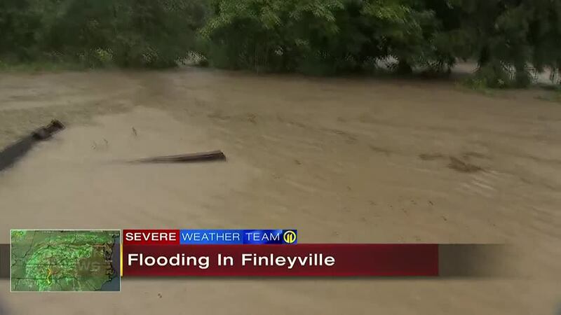
UPDATE 6:15 p.m.: There is widespread flooding in the Finleyville area. Channel 11′s Jillian Hartmann was along Peters Creek in that area and found the water all the way up to the bottom of a bridge. A nearby home was also underwater.
The water continues to rise higher at Peters creek. It’s risen several inches so far. Some people can’t get to their homes right now due to flooded roads pic.twitter.com/fv9TL8dkzp
— Jillian Hartmann WPXI (@JillianWPXI) August 31, 2021
UPDATE 6:05 p.m.: There is extensive flooding along Pine Creek in the Wexford area. A viewer sent us video of an abandoned vehicle in the high water as emergency crews closed a stretch of road.

UPDATE 5:53 p.m.: A Flash Flood Warning has been issued for parts of Washington and Allegheny counties. A Flash Flood Warning was already issued and expired earlier Tuesday afternoon for many of these same areas, leading to increased concerns over the scale of flooding.
Flash Flood Warning including Bethel Park PA, Upper Saint Clair PA, Washington PA until 7:45 PM EDT pic.twitter.com/9gpggW7CM2
— NWS Pittsburgh (@NWSPittsburgh) August 31, 2021
UPDATE 5:44 p.m.: Emergency officials in Westmoreland County are preparing for what could be a major flooding event across the region. Small creeks and streams are already running high after heavy rains fell Tuesday afternoon.
The director of public safety for the county, Bud Mertz, said the county is preparing to activate its emergency operations center.
“We’re going to activate early tomorrow morning and we expect to be running 24 hours straight through the event,” he said.
UPDATE 5:08 p.m.: About 120 Pennsylvania National Guard members have been activated ahead of the remnants of Hurricane Ida moving over Pennsylvania. The soldiers and airmen are staged at various places around the state along with about 35 high-water capable vehicles.
Two helicopters and crews with the Pennsylvania Helicopter Aquatic Rescue Team are also on stand-by.
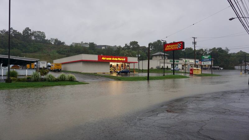
UPDATE 4 p.m.: A Flood Advisory has been issued for parts of Allegheny, Washington and Westmoreland counties. The National Weather Service reports between 1 and 1.5 inches of rain have already fallen. Locations impacted Pittsburgh, Penn Hills, Bethel Park, Monroeville, McMurray, McKeesport, Jeannette, Canonsburg, Gastonville, Plum, West Mifflin, Baldwin, Upper St. Clair, Murrysville, Whitehall, South Park Township, Munhall, Jefferson Hills, North Versailles and Brentwood.
The Flash Flood Warnings have been allowed to expire.
Tuesday afternoon’s rains are not associated with the remnants of Ida, but were instead a stalled frontal boundary. There could be minor flooding resulting from this.
UPDATE 3:55 p.m.: Water is flowing over the parking lot at Trax Farms in Finleyville. It’s likely also inside the store and restaurant. Video sent to Channel 11 from a viewer showed at least several inches of water flowing quickly after heavy rains moved through.
Flooding at Trax Farm in Finleyville @NWSPittsburgh @StephAllisonWx @WPXI pic.twitter.com/8YjxwzeEOZ
— Bill Mill (@BillMill96) August 31, 2021
UPDATE 3:48 p.m.: The Mon Wharf will be closed from Wednesday until further notice, according to the Public Parking Authority of Pittsburgh.
UPDATE 1:52 p.m.: Heavy rain is really coming down across the area. Channel 11′s Joe Arena encountered a downpour while on the road in Etna.
Coming down right now on just outside of Etna! FLASH FLOOD WARNING in effect til 4:30 and MORE strong stuff on the way! Get the app ===> https://t.co/rlsiSCDwCN pic.twitter.com/12cQqd97nW
— Joe Arena (@WPXIJoe) August 31, 2021
UPDATE 1:36 p.m.: The City of Pittsburgh is preparing for storm conditions as Ida travels up into the northeast corridor. The current forecast calls for excessive rain and possible flash flooding today and Wednesday.
The City is taking the following steps to prepare for the inclement weather:
- The Pittsburgh Water and Sewer Authority (PWSA) and Department of Public Works (DPW) are cleaning out catch basins and storm drains.
- Swift Water Flood Response teams comprised of Pittsburgh Fire, EMS, and Police will be staffed from midnight tonight and begin staging in areas of the City that are most susceptible to flooding. The Zodiac-type vessels are equipped with life-saving equipment and teams of four to eight specially trained personnel.
- DPW Street and Forestry crews are preparing to address downed trees and other debris that may block streets.
- Department of Permits, Licenses and Inspections (PLI) electrical inspectors will be on-call to address any large-scale power outages.
UPDATE 1:28 p.m.: A Flash Flood Warning has been issued for parts of Allegheny and Westmoreland counties until 4:30 p.m.
Thunderstorms that could produce 1 to 2 inches of rain is moving through the area.
Flash Flood Warning including Pittsburgh PA, Bethel Park PA, Monroeville PA until 4:30 PM EDT pic.twitter.com/cTbCv3Oinm
— NWS Pittsburgh (@NWSPittsburgh) August 31, 2021
Original Story
Rain will overspread the region late Tuesday evening and pick up in intensity after midnight. Rain will be heavy on and off through Wednesday, with the heaviest rain south and east of Pittsburgh.
>>STORY: Rain from Ida likely to bring flooding to parts of southwestern Pennsylvania
A flash flood watch will be in effect Wednesday for much of the area from Washington, Allegheny, Armstrong and Indiana counties and south. As much as 6 inches of rain are possible in parts of Westmoreland, Fayette and Greene counties before rain tapers off Wednesday night.
If you want to receive alerts about weather, download our Severe Weather Team 11 app.
Watch for flash flooding during the day Wednesday. Keep an eye on streams and creeks, as well as traditional low-lying areas. River flooding along the Monongahela and Youghiogheny rivers will become a bigger concern by Thursday and Friday as water rushes down the hills and mountains into area tributaries.
>>STORY: Ida downgraded to a tropical depression as heavy rains soak southern states
Stay with Severe Weather Team 11 on all of our platforms as we continue to track the impacts of Ida on our area and where high-water issues will be the worst.
TRENDING NOW:

Cox Media Group
/cloudfront-us-east-1.images.arcpublishing.com/cmg/XCUXZC2XYZHCRGNNGKFEX6U3LQ.png)


