PITTSBURGH — The snow has mostly subsided for now as we head into the weekend. Bitter cold wind chills and a chance for light snow are what we are tracking next.
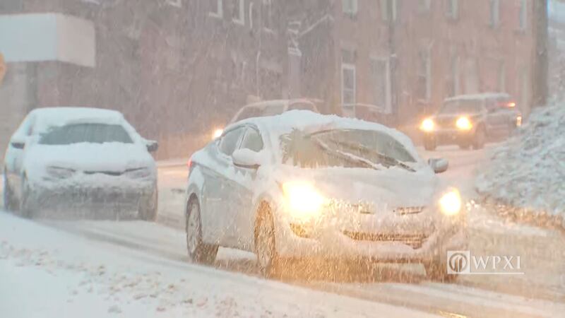
Snow fell for several hours Friday across the area. The steadiest of it came during the height of the morning commute.
For the latest updated forecast, click here.
UPDATE 5 p.m.: Snow showers are still lingering in spots around the region as cold air wraps around behind the system that dumped several inches during the morning rush.
There could be some snow showers for parts of the weekend as well.
UPDATE 1 p.m.: Scattered snow showers will continue this afternoon with gusty winds keeping wind chills in the teens.
Snow will continue to taper off into the evening.
Watch for slushy side roads turning icy tonight.
PennDOT has also lifted speed reductions on I-80 in Butler, Clarion and Jefferson counties. Additionally, commercial vehicles are no longer restricted to only traveling in the right lane.
If you want to receive ALERTS about weather and traffic, download our Channel 11 News and Severe Weather Team 11 apps.
UPDATE 12 p.m.: The timing of Friday morning’s snow caused major issues for drivers.
In Pittsburgh’s North Side, side streets quickly became messy and many people were forced to stay home for the day. Plows and salt trucks treated the side roads, but the snow fell quickly over a short stretch of time.
Cars were seen slipping and sliding on streets, such as Federal and Henderson streets, during the morning commute.
Watch WPXI’s Mike Holden’s report below:
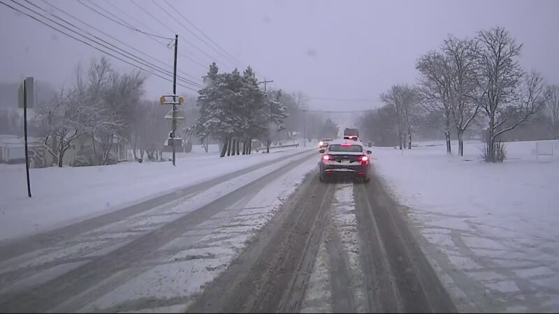
Driving was also tricky Friday morning in Butler County as the snow picked up in intensity.
“I just seen it literally from the beginning before it started, and then next thing you know, everything was covered by 9 a.m.,” Chelsey Rock, who was driving in the area, said.
Watch WPXI’s Liz Kilmer’s report below:
Friday’s snow was the first significant weather event of the winter.
“This used to be a normal snow, but this winter it’s like our first actual snow of the year, so we’re not really used to it,” Eve Alden, a North Side resident, said.
UPDATE 11:10 a.m.: The following warming centers are available in Beaver County:
- The Cornerstone – 600 6th Street Beaver Falls
- New Brighton Municipal Building – 610 Third Ave New Brighton
- Uncommon Grounds Café – 380 Franklin Avenue Aliquippa
- The Center for Hope – 740 Park Road Ambridge
CLICK HERE for more information about the warming centers and their hours.
UPDATE 10:30 a.m.: PennDOT has lifted a speed limit restriction on Interstate 376 (Beaver Valley Expressway) in Beaver and Lawrence counties.
UPDATE 8 a.m.: Most areas will end up with at least 2 inches of snow, with many closer to 4 inches.
If you want to receive ALERTS about weather and traffic, download our Channel 11 News and Severe Weather Team 11 apps.
Most areas will end up with at least 2"...many closer to 4". Biggest snowfall so far this season.
— Scott Harbaugh (@WPXIScott) February 7, 2020
Live streaming now for your convenience ---> https://t.co/mmXOytnrtc pic.twitter.com/R2OGL7jY2n
UPDATE 7:45 a.m.: PennDOT has reduced the speed limit on Interstate 80 in Butler, Clarion and Jefferson counties to 45 mph. Commercial vehicles are restricted to the right lane while the speed reduction is in place.
TRAFFIC: PennDOT has reduced the speed to 45 MPH on Interstate 80 in Butler, Clarion and Jefferson counties.
— WPXIJennifer Tomazic (@JenniferTomazic) February 7, 2020
UPDATE 7:35 a.m.: The speed limit on Interstate 376 (Beaver Valley Expressway) in Beaver and Lawrence counties has been temporarily reduced to 45 mph, according to the Pennsylvania Department of Transportation.
TRAFFIC: PennDOT has reduced the speed on 376 in Beaver and Lawrence Co. to 45 mph. Follow @WPXITraffic for updates.
— WPXIJennifer Tomazic (@JenniferTomazic) February 7, 2020
UPDATE 6:35 a.m.: Channel 11′s Trisha Pittman says she’s following more than a dozen crashes (CLICK HERE for LIVE updates) across the area as snow and winds pick up.
If you want to receive ALERTS about weather and traffic, download our Channel 11 News and Severe Weather Team 11 apps.
UPDATE 6 a.m.: Snow is covering many roads, creating slick conditions for drivers. Several crashes have been reported throughout the Channel 11 News viewing area.
SLOW GOING on the North Side. Lots of brake lights. Lots of sliding. Be careful, guys! Updating you in live reports all morning on @WPXI. Stay with us & WATCH Channel 11! pic.twitter.com/SDHC7k7xpz
— Mike Holden (@WPXIMikeHolden) February 7, 2020
UPDATE 5:30 a.m.: Snow is picking up in the Pittsburgh area. Streets in the North Side are starting to pick up a coating of snow.
Snow fall has really picked up here on the North Side. Be safe! I’m live at 5:30 showing you the ever changing conditions. WATCH @WPXI NOW-7 a.m. pic.twitter.com/jTN50i845e
— Mike Holden (@WPXIMikeHolden) February 7, 2020
UPDATE 4:50 a.m.: Snow is starting to stick in parts of the area as precipitation transitions from a mixture of rain, snow and sleet.
Snow is sticking to the roads. This is 228 in Seven Fields. Live team coverage at 5! @wpxi pic.twitter.com/3B66187P9J
— Liz Kilmer (@LizKilmerWPXI) February 7, 2020
UPDATE 3:45 a.m.: You’ll need patience and some good tire treads to get out and about Friday morning.
Snow will be steady at times through the morning, eventually tapering off to scattered snow showers by late morning.
The steadiest snow will fall from 6 a.m. to 9 a.m. across the area, leading to snow-covered roads and very slow travel. Road temperatures will be cold enough for snow to stick and become icy if not treated.
The afternoon will bring in colder air, with wind chills in the teens and wind gusts to 30 mph.
Rain, snow, sleet will change to all snow before sunrise leading to a very tricky morning commute. We're going on live at 4am with Severe Weather Team 11 coverage on @WPXI pic.twitter.com/WcjjMAhb8u
— Scott Harbaugh (@WPXIScott) February 7, 2020
ORIGINAL STORY: Allow some extra time to clear your car, shovel the sidewalk and sit in traffic early Friday-with snow developing before sunrise and continuing off and on through the day.
NEW Winter Weather Advisory just issued. Snow moving in overnight-messy morning commute ahead. NEW timing next Channel 11 News 5pm. pic.twitter.com/C4F2UPN9Qy
— Stephen Cropper (@WPXICropper) February 6, 2020
The current forecast shows several hours of steady snow, especially during the morning commute-which will make it hard for crews to keep up.
Road temperatures will be cold enough for snow to stick, and become icy if not treated.
If you want to receive ALERTS about weather, download our Severe Weather Team 11 App.
The steadiest snow is expected through noon, with scattered snow showers and wind chills in the teens the rest of the day.
TRENDING NOW:
© 2020 Cox Media Group
/cloudfront-us-east-1.images.arcpublishing.com/cmg/XCUXZC2XYZHCRGNNGKFEX6U3LQ.png)


