PITTSBURGH — Severe Weather Team 11 tracked the rain and storms that moved through Western Pennsylvania.
Watch Channel 11 News - or when we’re not on the air - you can get updates in our FREE Severe Weather Team 11 app for iOS and Android.
>>>TRACK THE RAIN AND STORMS WITH OUR LIVE INTERACTIVE RADAR<<<
5:58 a.m. UPDATE:
Storms have brought trees down in Washington County. Right now, there are just under 1,000 West Penn Power customers without power.
Trees down all over Washington County. Just under 1,000 West Penn Power customers without power in Wash Co. @WPXIScott is tracking another round of heavy rain, lightning, and strong winds. Flip on @WPXI NOW or watch live here ➡️ https://t.co/2QyZTb8QSA pic.twitter.com/dq7Ks0JhoN
— Alyssa Raymond (@AlyssaRaymond) June 14, 2022
4:45 a.m. UPDATE:
Expect a bumpy ride at times to start the day Tuesday, especially from Pittsburgh and south.
A few more rounds of showers and thunderstorms will roll through the area during the morning commute. A few severe storms with 55+ mph wind gusts are possible and repeated rounds of heavy rain could lead to localized flooding. Showers and storms will shut off by lunch with clouds slowly heading out this afternoon.
2:05 a.m. UPDATE:
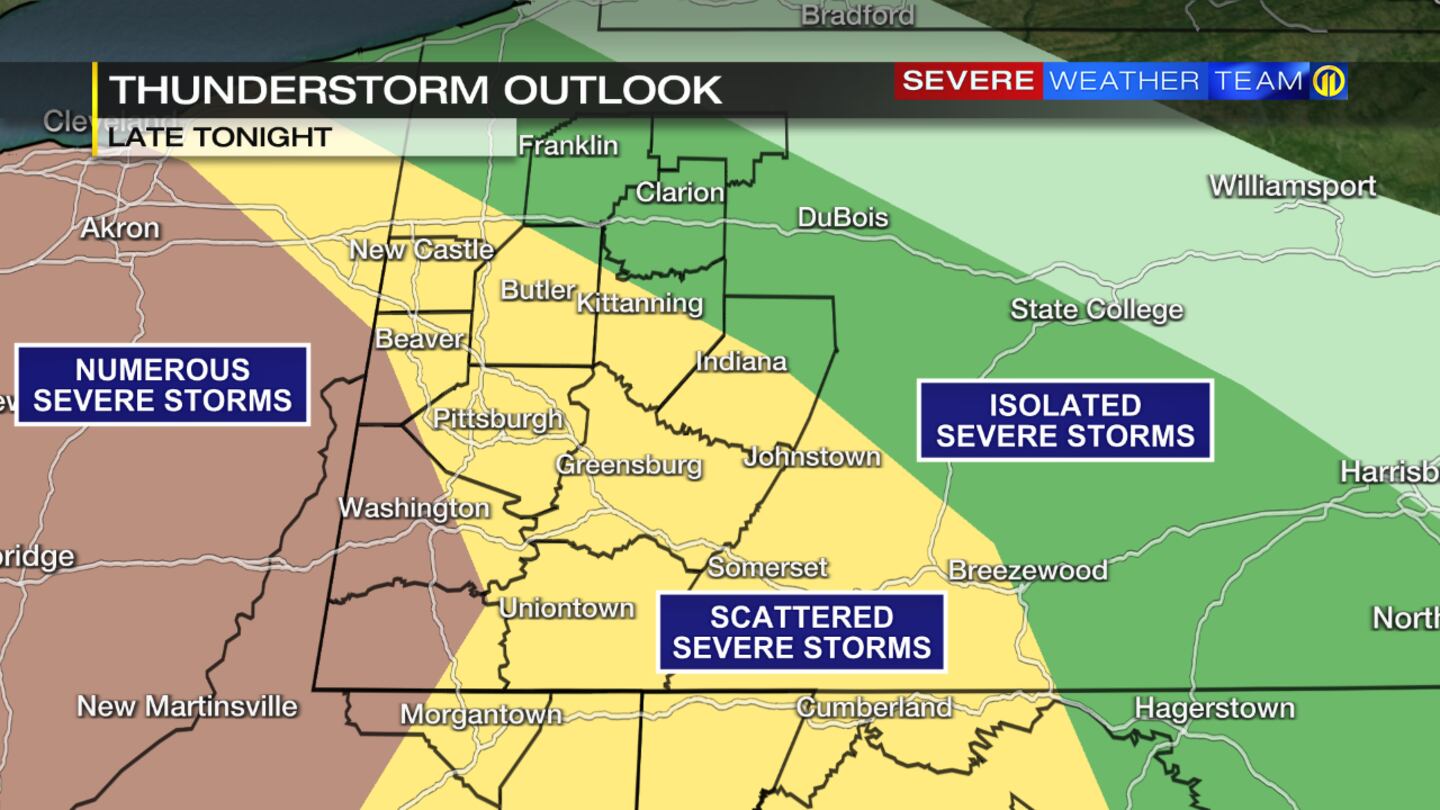
The first round of storms moved through Washington County and southern Allegheny County around 1:30 a.m., packing lightning and strong winds. More storms are expected to roll through the region during the morning commute and could impact Pittsburgh.
The National Weather Service issued a Severe Thunderstorm Watch for much of the area until 6 a.m. Tuesday.
Stay with Severe Weather Team 11 for updates on our news and weather apps. Channel 11 Morning News will start at 4:30 a.m.
If you have pictures or video of storms in your neighborhood, and you can send them safely, you can email desk@wpxi.com or tag us on Facebook, Twitter, or Instagram.
Round #1 has weakened as it exits the area. Attention now turns to Round #2, which is just now pushing into norther Ohio from Michigan. This will move through portions of the area early this morning with additional potential for severe thunderstorms. pic.twitter.com/YqmcbqEWtW
— NWS Pittsburgh (@NWSPittsburgh) June 14, 2022
RELATED >> Overnight thunderstorms with heavy rainfall could damage region, knock out power
1:03 a.m. UPDATE:
A Severe Thunderstorm Warning has been issued for parts of Washington, Beaver, and Greene counties until 1:45 a.m. Winds could gust up to 70 MPH.
SEVERE THUNDERSTORM WARNING has been issued for the shaded portion of Washington county. Take precautions now.
— Scott Harbaugh (@WPXIScott) June 14, 2022
Interactive radar: https://t.co/FZ9C6meUjq
Download the FREE Severe Weather Team 11 App for alerts: https://t.co/SNtbZ2FQ77 #WPXI #WPXIStorm #SevereWeather #PAWX pic.twitter.com/PzU2aAjzos
Original story:
OVERVIEW:
A strong line of storms is now organizing and moving into northwest Ohio, approximately 300 miles away. Right now, it’s moving E/ESE at 40-50 mph, with winds now at 60-70 mph. Watching the movement and speed now, I think it may really pick up speed shortly. The storms will be moving through the Ohio Valley over the next several hours. This line has the potential to produce destructive winds for Ohio and the potential for damaging winds for our area.
Still watching the movement and speed, monitoring if it comes directly through our area.
Channel 11 will continue to update as this develops this evening and overnight.
TIMELINE
Now-12 a.m.
Mostly calm and quiet, but an isolated thunderstorms could pop ahead of this system.
12 a.m.-2 a.m.
Stronger storms may start to move in, but probably more towards the 2 a.m. timeframe.
2 a.m.-6 a.m.
Line should come in from the W/NW from the Ohio Valley.
6 a.m.-8 a.m.
Still see the potential for isolated severe storms.
8 a.m.-11 a.m.
Lingering leftover showers and isolated storms, but tapering off towards late morning.
Threats:
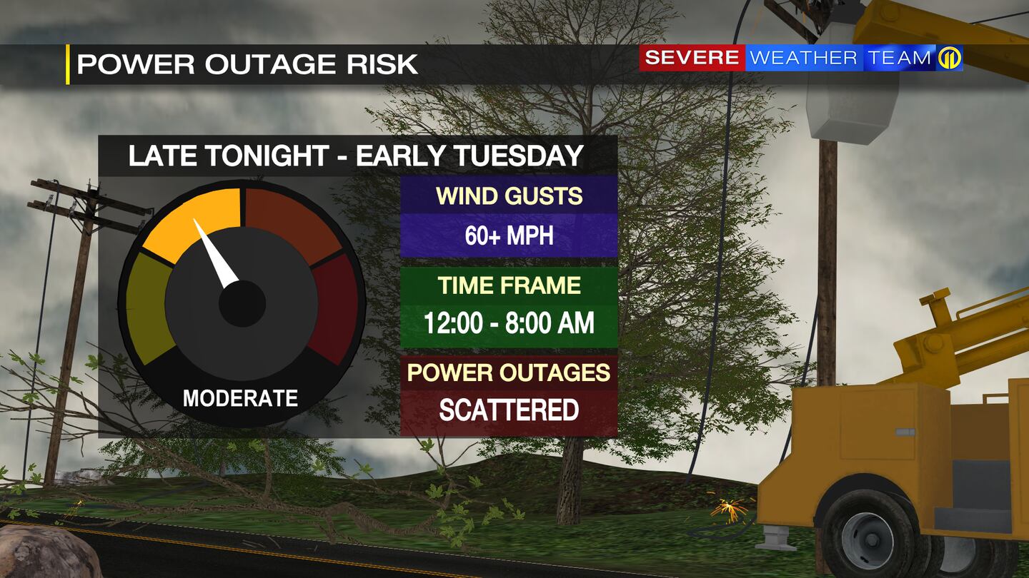
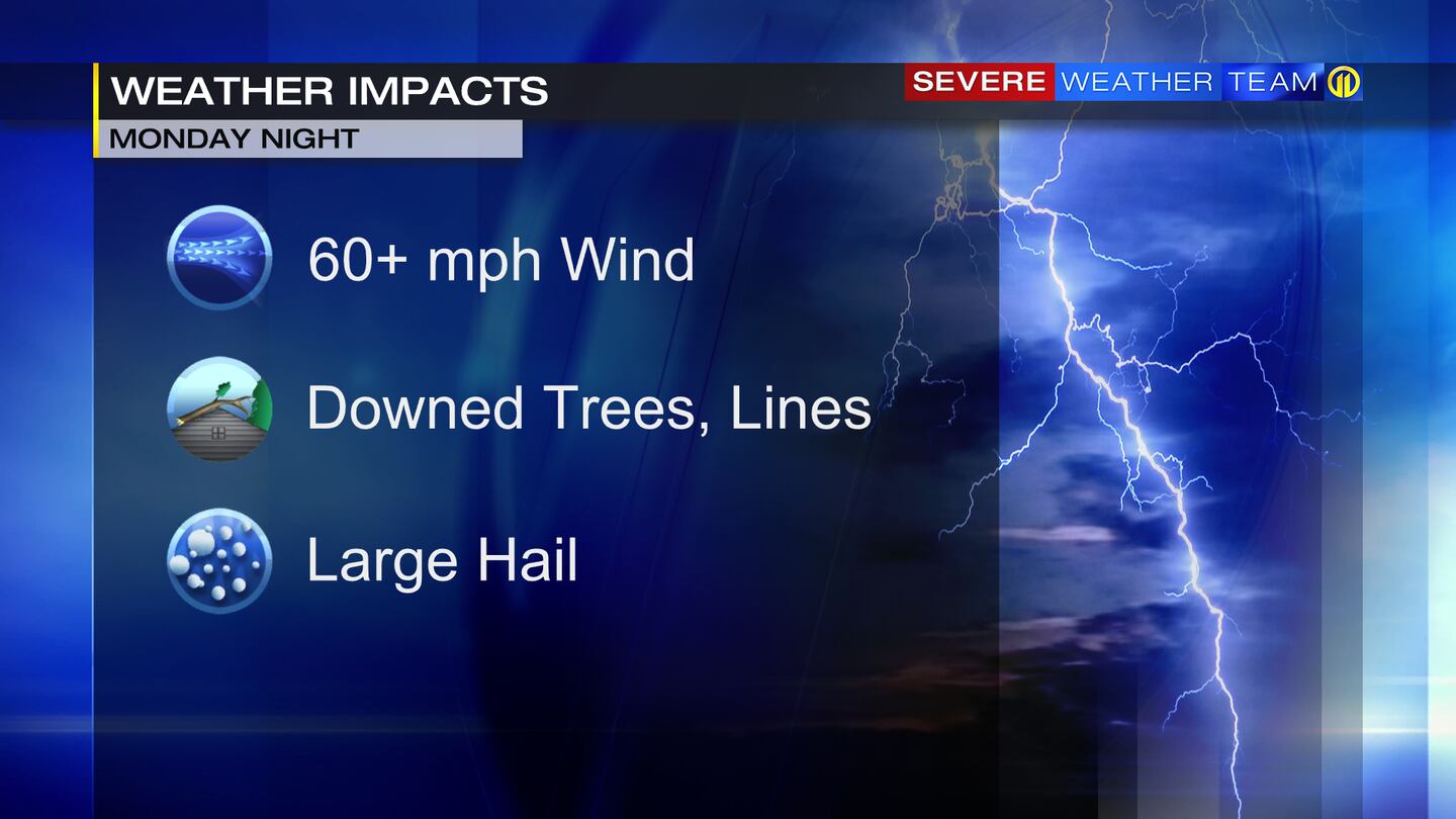
Damaging Winds = right now, we can say 60+ mph
(worst case scenario = 70+ mph winds)
Heavy rain (flooding potential possible as this develops, depends on speed and rainfall rates)
Large Hail
Isolated Tornados (better chances in Ohio)
What could change:
Timing and severity, depending on development and movement.
©2022 Cox Media Group
/cloudfront-us-east-1.images.arcpublishing.com/cmg/XCUXZC2XYZHCRGNNGKFEX6U3LQ.png)