
PITTSBURGH — UPDATE 11 p.m. -- All watches and warnings have expired.
UPDATE 10:30 p.m. -- Waves of wet weather with possible storms will continue over the next several days.
The main concern is heavy rain with localized flooding, strong damaging winds and hail, as well as increased land slide problems.
UPDATE 8 p.m. -- A Severe Thunderstorm Warning has been issued for parts of Greene and Washington counties until 8:45 p.m.
UPDATE 4:54 p.m. -- A Severe Thunderstorm Warning has been issued for Fayette, Greene, and Washington County until 5:45 p.m.
UPDATE 4:25 p.m. -- A Severe Thunderstorm Warning has been issued for part of Washington County.
WEATHER ALERThttps://t.co/pmwncDzuHb | https://t.co/5TuINuXud7 | https://t.co/jMjzNKJQ6v | https://t.co/kXBEdLY2tR pic.twitter.com/1fKf46Sxkc
— WPXI (@WPXI) May 13, 2018
UPDATE 4:10 p.m. -- Strong storms, including heavy downpours, gusty winds and hail are moving through the area.
UPDATE 2:30 p.m. -- Though there are no watches or warnings right now, another round of storms is headed toward Western Pa.
According to the National Weather Service, there is a 60 percent chance that most parts of the viewing area will be issued a severe thunderstorm watch.
There’s a 60% chance of a WATCH being issued for parts of our area. Stay weather aware— #PAwx pic.twitter.com/d1eT8aOGur
— Danielle Dozier WPXI (@DanielleDozier) May 13, 2018
UPDATE 8:20 a.m. -- Several counties are under severe thunderstorm warnings.
Click HERE for a LIVE Interactive Radar
The counties affected include Allegheny, Beaver, Butler, and Lawrence counties.
WEATHER ALERThttps://t.co/CxqkEljroS | https://t.co/ym2MDP8I4G | https://t.co/nvDLl8sHag | https://t.co/j8HsxbziQw pic.twitter.com/SZPUquRuFX
— Stephen Cropper (@WPXICropper) May 13, 2018
The warning is in effect until 8:45 a.m., according to the National Weather Service.
Several waves of wet weather, with possible severe storms, are likely throughout the day Sunday.
The system is very complicated, which makes it difficult to predict timing and location with precision. The storm front remains draped over the region.
Heavy rain with localized flooding, strong winds and hail remain the biggest concerns going into Mother's Day.
UPDATE 8:25 p.m.
Flash flood warnings have begun to come in for several areas, including Westmoreland County, in effect until 11:15 p.m.
STORM TRACKER: Hour-by-hour look at weekend showers, storms
UPDATE 7:45 p.m. -- The National Weather Service has canceled the severe thunderstorm watch for all areas in our viewing area. Showers that could turn into thunderstorms are moving east of Pittsburgh over the next few hours.

However, another round of showers is expected to enter our area overnight into Sunday morning.
A flood advisory was issued for parts of Allegheny, Westmoreland, Cambria and Somerset counties -- in effect until 10:15 p.m.
UPDATE 7 p.m. -- Heavy rain, winds, and hail are coming down all across Western Pa.
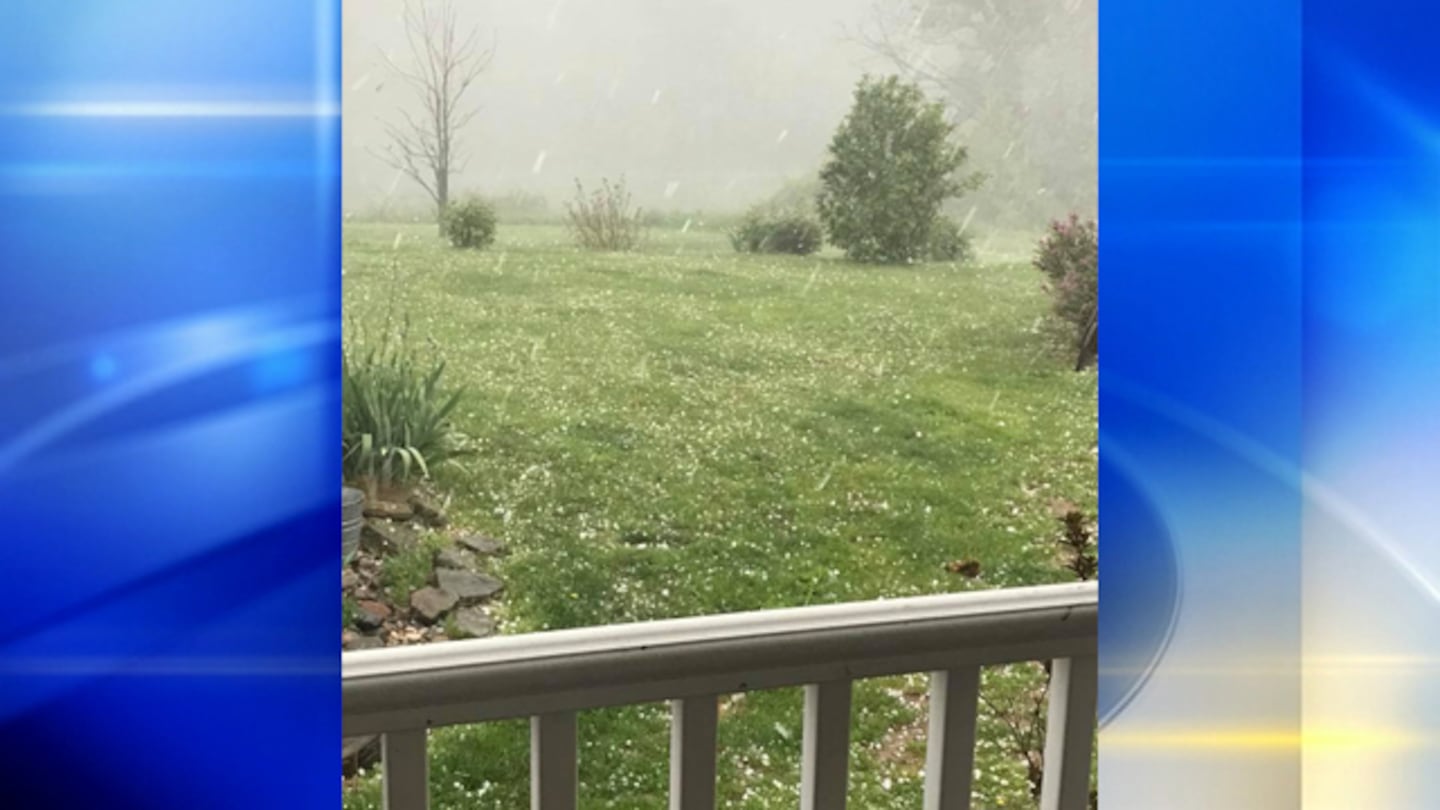
Photos like these have been flooding in, showing hail upwards of half an inch thick.
The entire viewing area remains under a severe thunderstorm watch until 11 p.m.
UPDATE 5 p.m.
4:53 pm: Storm rolling through Beaver Falls now, bowing out, may produce wind gusts to 35 & 40 mph. #PAwx #WPXIStorm @wpxi pic.twitter.com/hSt1qlOz43
— Danielle Dozier WPXI (@DanielleDozier) May 12, 2018
UPDATE 4:15 p.m.
WEATHER ALERT... Severe Thunderstorm Warning for Fayette and Westmoreland County until 5:15pm. https://t.co/5TuINuFSOx | https://t.co/jMjzNL1qY3
— WPXI (@WPXI) May 12, 2018
UPDATE 4:10 p.m. -- The National Weather Service just issued a severe thunderstorm warning to Washington County, effective until 4:45 p.m.
South Park is also under a warning until 4:45 p.m., in addition to the other areas already announced by the NWS.
UPDATE 4 p.m. -- Several areas are now under severe thunderstorm warnings, according to the National Weather Service.
Severe Thunderstorm Warning including Bethel Park PA, Upper Saint Clair PA, Whitehall PA until 4:45 PM EDT pic.twitter.com/JMuVimWT91
— NWS Pittsburgh (@NWSPittsburgh) May 12, 2018
Multiple municipalities in Allegheny County, including Bethel Park, Upper Saint Clair, and Whitehall are all under the warning until 4:45 p.m.
3:55 pm: SVR T-Storm Warning inc. Washington, Bethel Park. 60 mph winds/half-dollar sized hail, moving east. #PAwx pic.twitter.com/VZG1DA49Kd
— Danielle Dozier WPXI (@DanielleDozier) May 12, 2018
Other areas are under warnings until 4:15 p.m., the NWS said, inlcuding Monroeville, Plum, and Murrysville.
The rain is starting to move through. This was from the down pour that happened a little bit ago. Watch @WPXI tonight for your latest forecast. pic.twitter.com/8MbbwamVg8
— Jamie Cashdollar (@Cashmoney2292) May 12, 2018
UPDATE 3:45 p.m. -- Severe Weather Team 11 continues to track heavy rain entering our area, which could bring strong winds, hail, and possible tornado watches in some areas.
The severe thunderstorm watches are still in effect for multiple counties, with wind speeds upwards of 60 miles per hour and a potential of one inch of hail moving east.
The National Weather Service also issued severe thunderstorm warnings to the following counties: Allegheny, Armstrong, Indiana, and Westmoreland. Those warnings are in effect until 4:15 p.m.
3:25 pm: SVR T-Storm Warning for cities in yellow box. 60 mph winds/1” hail possible, moving east. #PAwx pic.twitter.com/5yxQXY42SD
— Danielle Dozier WPXI (@DanielleDozier) May 12, 2018
UPDATE 2:48 p.m. - A severe thunderstorm watch has been issued for Allegheny, Armstrong, Beaver, Butler, Fayette, Indiana, Washington and Westmoreland counties until 11 p.m.
WEATHER ALERT... Severe Thunderstorm Watch for Allegheny, Armstrong, Beaver, Butler, Fayette, Greene, Indiana, Washington and Westmoreland County until 11:00pm. https://t.co/5TuINuFSOx | https://t.co/jMjzNL1qY3
— WPXI (@WPXI) May 12, 2018
Showers and thunderstorms are likely today, especially in the afternoon.
STORM TRACKER: Hour-by-hour look at weekend showers, storms
Some of these storms may be strong to severe, with a threat for damaging winds, hail and heavy downpours. Highs will be in the upper 70's.
DOWNLOAD THE SEVERE WEATHER TEAM 11 APP
Sunday, Mother's Day, will also be wet. We'll see showers, with the potential for a few thunderstorms. Highs will be in the mid-70s.
We will be tracking unsettled weather through the weekend and into next week. Stay alert to changing weather conditions.
The main concern over the next few days will be flooding downpours and damaging wind.
Stay with Severe Weather Team 11 for the latest on any severe weather this weekend.
TRENDING NOW:
- Police put driver in custody after 2-county car chase ends
- National phone scam busted; alleged ringleader in custody in Pittsburgh
- 2018 Best high schools in Pennsylvania, according to new rankings
- VIDEO: Police searching for 3 suspects after overnight chase
 |
 |
 |
 |
Cox Media Group
/cloudfront-us-east-1.images.arcpublishing.com/cmg/XCUXZC2XYZHCRGNNGKFEX6U3LQ.png)


