PITTSBURGH — This massive, complex weather system pushing through western Pennsylvania is dropping rain, ice and snow.
A FLOOD WARNING is in effect for parts of Allegheny, Fayette, Greene, Indiana, Washington and Westmoreland counties until 7 p.m. Friday.
BE SURE TO DOWNLOAD THE FREE SEVERE WEATHER TEAM 11 APP TO STAY AHEAD OF THIS POTENTIALLY DANGEROUS SYSTEM.
UPDATES
UPDATE 6:30 p.m.: “If you don’t salt behind that plow, it will turn into an icy snow pack and make it disastrous with the temperatures dropping tonight,” PennDOT plow truck operator Chris Heinack told Channel 11.
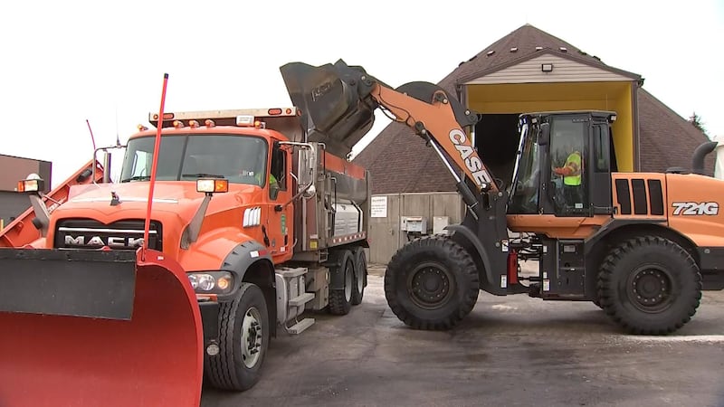
All day, around 40 crews were busy in Butler County trying to get the slushy mess of the roads before it turned to ice.

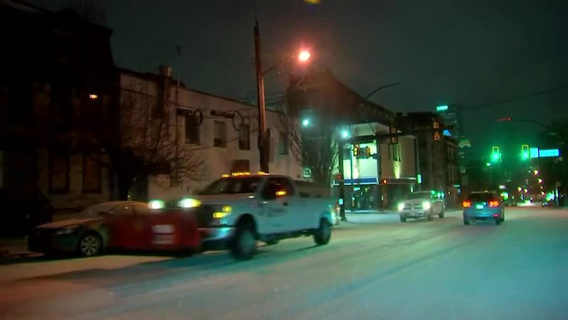
UPDATE 5:30 p.m.: Snow and ice covered streets on the Northside and in Downtown Pittsburgh had some people feeling salty Friday morning.
“A trip that normally takes me an hour to do took me almost two hours,” said Heath Black.
“Today is a little tricky. When I was out shoveling the snow from my sidewalk, it was like shoveling sand. Grainy, icy and horrible. The roads are slushy but passable,” said Edmond Ashburner.
UPDATE 5:00 p.m.: “It’s frozen as soon as it hits the ground,” said Bob Vavra who works at a rest stop along I-79. “It started coming down in pellets.”
It slowly went from rain, to freezing rain, to ice and then to snow at the Washington, Allegheny County line.
Temperatures are going to take a few days to warm up so the ice problem may continue to stick around a little while.

UPDATE 4:30 p.m.: The cleanup sounds a bit different than the storm in Beaver County.
“First off it was a loud bang it was the first tree in the back then you heard branches falling a little bit more,” said Matthew Lawless who lives in Hopewell Township.
Twigs, branches, and literal trees surround Lawless Friday afternoon as he surveys the damage.
“It was very scary I have a newborn right now and we huddled in the living room because we felt that was the safest room away from tall the trees, we were just very scared all night,” Lawless said.
For those without power in this township, the fire department opened its doors with the Red Cross to serve as a warming shelter. It will be open for as long as it’s needed.
UPDATE 1 p.m.: Flooding has Armbrust Road in Hempfield Township closed.
LATEST -> Armbrust Road in Hempfield Twp still shut down due to flooding, talked to a neighbor here who says they’re used to this — they’re hunkered down and can’t leave until water recedes #WPXI pic.twitter.com/fAyqxHfWOS
— Melanie Gillespie (@WPXIMelanie) February 4, 2022
UPDATE 11:30 a.m.: In Beaver County, the following warming shelters are available:
- The Cornerstone of Beaver County - 600 6th Street, Beaver Falls (Monday - Friday 9 a.m. - 4 p.m.)
- Trails Ministry - 1217 7th Avenue, Beaver Falls (Monday - Friday 9 a.m. - 5:30 p.m.)
- Central United Methodist Church - 1227 6th Avenue, Beaver Falls
- New Brighton Municipal Building - 610 3rd Avenue, New Brighton (Monday - Thursday 8:30 a.m. - 4 p.m.)
- Rochester Free Methodist Church - 480 Jefferson Street, Rochester (Call ahead at 724-774-5304)
10 a.m.: One person was rescued after driving through high water in Youngwood on Hillis Road.
Thanks to @Firechief26 for these pics of the water rescue in Youngwood this morning — one person was rescued after driving through high water on Hillis Road, 911 urging folks to not drive thru flooded roadways.. #WPXI pic.twitter.com/oZJKMbKiBx
— Melanie Gillespie (@WPXIMelanie) February 4, 2022
UPDATE 8:45 a.m.: Route 982, near Mission Road, in Latrobe is closed due to flooding. The water is subsiding.
Route 381, near Route 30, in Ligonier Township is also closed due to flooding.
There were several water rescues in Westmoreland County this morning, officials said.
NOW -> Route 982 near Mission Road in Latrobe closed due to flooding, water is subsiding, Route 381 near 30 in Ligonier Twp is closed due to flooding, 3 roads in Hempfield Twp closed, 911 urging people to not drive through flooded roadways after several water rescues this AM pic.twitter.com/OKZZfRukwi
— Melanie Gillespie (@WPXIMelanie) February 4, 2022
UPDATE 8:40 a.m.: A swift water rescue team rescued one person from their home on Celia Drive in Franklin Township when water rose from the Connoquenessing Creek early this morning, Beaver County officials said.
#NEW Beaver County confirms to me that in the early morning hours the swift water rescue team rescued one resident from their home after rising floodwaters from the Connoquenessing Creek. This happened on Celia Drive in Franklin Twp. The resident is safe. @WPXI pic.twitter.com/zMfmTkDRve
— Nicole Ford (@NicoleFordTV) February 4, 2022
UPDATE 8:25 a.m.: Butler PennDOT had about 40 trucks out this morning treating and plowing the roads. They are working around-the-clock to clear the roads. They are trying to take care of the interstate and 422, and then other traffic routes and secondary roads.
They are getting some reports of trees down and blocking roadways, mostly in the northern part of the county. One tree is blocking state road 528 at Moraine State Park.
ROAD CONDITIONS: This part of Route 228 in Cranberry looks good for the most part. There’s also not much traffic so far this morning. @WPXI pic.twitter.com/74w8oLdEVv
— Jillian Hartmann WPXI (@JillianWPXI) February 4, 2022
UPDATE 7:10 a.m.: A portion of the overhead power line went down near the Port Authority of Allegheny County’s rail center in the South Hills. Here’s what a spokesperson said about it.
“A portion of the overhead power line went down near the rail center in the South Hills this morning, trapping all of our rail cars and rendering the line all but unusable. Needless to say, there are significant delays.
“One rail car was out at the time and will be used to serve the Silver Line from Library to downtown and back.
“A bus shuttle is operating between South Hills Village and downtown but is only able to serve high-level platform stops.
“Buses are experiencing little delays other than in hilly areas that we are unable to traverse, specifically parts of Penn Hills and the Polish Hill neighborhood of Pittsburgh.
“With temperatures not expected to rise much throughout the day, quick repairs and restoration of the rail system will be difficult but our crews are out there trying as hard - and as quickly - as they can.”
A portion of the overhead power line went down near the rail center in the South Hills this morning, trapping all of our rail cars and rendering the line all but unusable. Needless to say, there are significant delays.
— Port Authority PGH (@PGHtransit) February 4, 2022
UPDATE 6:12 a.m.: A tractor-trailer crash on the Pennsylvania Turnpike has all lanes blocked eastbound near the Warrendale toll plaza.
TRACTOR TRAILER CRASH on the PA Turnpike Eastbound near the Warrendale Toll Plaza. All Lanes Currently Blocked. #PittsburghTraffic #WPXI https://t.co/UyYsfsftyh pic.twitter.com/B4Oz1aEAor
— WPXI Traffic (@WPXITraffic) February 4, 2022
UPDATE 5:15 a.m.: More than 25,000 people are without power throughout western Pennsylvania as ice and snow accumulate.
>>>STORY: More than 25,000 without power throughout western Pennsylvania as snow, ice accumulate
UPDATE 3:25 a.m.: Here’s a look at snow falling in Beaver.
❄️ 3:20 AM — Snow is falling in Beaver. @WPXI pic.twitter.com/RLIzytA3BN
— Pete DeLuca WPXI (@PeteDeLucaTV) February 4, 2022
UPDATE 2:55 a.m.: It’s icy along I-79 at the Washington-Allegheny county line. The ice is coating surfaces.
2:50 AM UPDATE: Icy conditions along I79 at the county line between Washington & Allegheny. Ice coating surfaces. @WPXI @WPXIScott #PAwx pic.twitter.com/NnhHpGZNZO
— Alyssa Raymond (@AlyssaRaymond) February 4, 2022
UPDATE 2:25 a.m.: Sleet and freezing rain are still falling in many areas.
Road conditions right now. Sleet and freezing rain still falling in many areas. Be very careful. pic.twitter.com/C4cYMQOMb4
— Scott Harbaugh (@WPXIScott) February 4, 2022
UPDATE 2:15 a.m.: Channel 11′s Alyssa Raymond says she can see and hear the transition from rain to an icy mix on I-79 near Southpointe in Washington County.
2:10 AM - Seeing and hearing the transition from rain to an icy mix. I79 near Southpointe. #Pawx @WPXI pic.twitter.com/PdGUjIuUpe
— Alyssa Raymond (@AlyssaRaymond) February 4, 2022
UPDATE 2:04 a.m.: The wintry mix and snow lines continue to slowly move east. Roads are slick where you have snow or a mix right now. Everyone will be snow by dawn.
RADAR UPDATE (2:04am) Mix and snow line continue to slowly move east. Roads are very slick where you have snow or a mix right now. Everyone will be snow by dawn.
— Scott Harbaugh (@WPXIScott) February 4, 2022
Get alerts: https://t.co/SNtbZ2FQ77 pic.twitter.com/TrHz0hqnvQ
UPDATE 11:00 p.m.: Channel 11′s crew in Butler County reports conditions in Cranberry are significantly worse than in the City of Butler. Roads are covered with snow and ice. Freezing rain is still falling. It is becoming difficult stop at traffic lights and stop signs. Many drivers have their hazard lights on.
Roads look worse here in Cranberry. We had very few issues on roads in Butler but slid at several stop lights here in Cranberry Twp. Took us about 45 minutes to get from downtown Butler to Freedom Rd in Cranberry Twp. @WPXI pic.twitter.com/j6mhMRZSn6
— Kayla Courvell (@KaylaCourvell) February 4, 2022
UPDATE 10:21 p.m.: State Route 2013 in Buffington and East Wheatfield Township is closed in both directions due to flooding.
PennDOT officials said the Indiana County road is between the intersections of Mack Drive and Plowman Road. It is estimated to stay closed until 10 a.m. Friday.
UPDATE 10:00 p.m.: Thousands of people across the region are dealing with power outages. In Washington County alone, there are more than 6,000 customers without power.
READ MORE: Thousands without power throughout the region as snow, ice move in
UPDATE 9:00 p.m.: Rain continues falling in areas of Pittsburgh and to the south and east. Channel 11′s crew in Beechview reports drivers not having any issues and the T is still running.
Another Channel 11 crew in Washington County is reporting steady rain continuing to fall.
Meanwhile, areas to the north and west are seeing some major ice accumulations. All of that is still predicted to move through the entire area, eventually changing over to snow for the morning commute on Friday.
UPDATE 8:00 p.m.: The ice has arrived in Center Township, Beaver County.
#NOW The ice is here. This woman is putting in the work to get her car clean in Center Township, Beaver County as freezing rain pelts her. @WPXI pic.twitter.com/QGB7zadwZY
— Nicole Ford (@NicoleFordTV) February 4, 2022
UPDATE 7:30 p.m.: Officials in Beaver County report they’re getting numerous phone calls for trees and wires down due to the ice and snow.
We are receiving numerous calls for trees and wires down throughout the county. Stay clear of downed power lines.
— Beaver Co. Emerg Svc (@BeaverCounty911) February 3, 2022
To report your power out:
Penn Power - 1-888-LIGHTSS
Duquesne Light - 1-412-393-7000#BeaverCounty
UPDATE 7:00 p.m.: Here are the latest power outages around the area:
Duquesne Light: 209 customers affected
West Penn Power (First Energy): 620 customers affected
UPDATE 6:30 p.m.: The Beaver Valley Mall closed its doors early to make sure all staff and customers could get home before the roads turned to ice.
The big focus for county officials was the bridges and overpasses. As soon as the rain turned to ice, crews were mobilized to start laying down salt and aggregate.
UPDATE 6:00 p.m.: The National Weather Service has issued a Flood Advisory for part of the region. This includes Allegheny, Armstrong, Beaver, Butler, Indiana, Washington and Westmoreland counties. Officials said minor flooding is occurring in low lying areas.
Specific areas impacted include Pittsburgh, Penn Hills, Mount Lebanon, Bethel Park, Ross Township, McCandless Township, Monroeville, Cranberry, Moon Twp., McMurray, McKeesport, Indiana, Butler, Washington, Franklin Park, Jeannette, Aliquippa and Canonsburg.
As precipitation continues to fall and increase in intensity, a Flood Advisory has been issued for portions of the northern WV panhandle, far ern OH, and portions of PA, including the Pittsburgh metro: pic.twitter.com/V7if3WZgda
— NWS Pittsburgh (@NWSPittsburgh) February 3, 2022
UPDATE 5:30 p.m.: FedEx Express is dealing with service disruptions across the eastern third of the United States due to this massive storm system.
Hubs in Memphis and Indianapolis experienced freezing rain and snow, leading to hazardous operating conditions. If you were expecting a package Thursday, it will likely be delayed, especially as the snow and ice move into western Pennsylvania.
UPDATE 5:00 p.m.: In Westmoreland County, roads remain wet in the area of the Route 30 and 66 interchange in the Hempfield area.
WX LATEST -> Here’s a look at Route 30 in Hempfield Twp, near 66 interchange — roads are wet and rain continues to fall, NWS issued flood warning for WesmtoCo until tomorrow morning #WPXI pic.twitter.com/Pal38gOGvC
— Melanie Gillespie (@WPXIMelanie) February 3, 2022
UPDATE 4:45 p.m.: PennDOT has implemented Tier 4 restrictions on all major highways in the Pittsburgh area. Tier 4 means no commercial vehicles, school buses, commercial buses, motor coaches, motorcycles, RVs, and passenger vehicles towing trailers are not allowed.
Speed limits have also been dropped to 45 mph.
This includes:
- Interstate 79
- Interstate 376 (between Business Loop 376 Exit 57 and the PA Turnpike in Monroeville)
- Interstate 279 (Parkway North)
- Interstate 579
- Route 28
UPDATE 4:30 p.m.: PennDOT officials report a portion of Route 48 (Long Run Road) in White Oak is closed due to flooding. The road is closed at the intersection of Cool Springs Road.
UPDATE 4:15 p.m.: The National Weather Service has issued a FLOOD WARNING for portions of the region as reports indicate many creeks and streams are nearing their banks, and water is rising in many low-lying spots. Areas that may see flooding include Morgantown, Wheeling, Greensburg, Fairmont, Washington, Uniontown, Jeannette, Latrobe, Connellsville, Waynesburg and others. This is in effect until 7 a.m. Friday.
https://t.co/Ko13SiCZCy pic.twitter.com/vkQ9j8YIux
— NWS Pittsburgh (@NWSPittsburgh) February 3, 2022
Have pictures of the snow, ice or freezing rain where you’re at? WE WANT THEM! Safely share your pictures and videos with us right here by clicking/tapping the link -->>> SHARE WITH US
UPDATE 4:00 p.m.: Here are the latest power outages from Duquesne Light and West Penn Power:
Duquesne Light customers affected: 266 (all of them in Plum 15239 zip code)
West Penn Power: 82 in Allegheny County, 18 in Armstrong County, 286 in Westmoreland County
UPDATE 3:45 p.m.: PennDOT officials in Butler told Channel 11 they will launch crews to start treating roads and highways once the rain slows down. They’ll continue to monitor the roads as they expect freezing rain, sleet and eventually accumulating snow.
Officials said their stockpiles of salt are full.
Crews in Butler County will be working 12 hour shifts around the clock until the storm has passed.
UPDATE 3:30 p.m.: The Mall at Robinson, South Hills Village and Ross Park Mall are all closing early Thursday due to the hazardous weather in the region.
UPDATE 3:15 p.m.: Remaining snow and slush on sidewalks and roads is expected to freeze and turn to solid ice as this system continues to move through Thursday evening.
This is the concern—already icy and slushy sidewalks, non-stop rain. Temps dropping as freezing rain moves in. @WPXI #wpxistorm Snapped pic in Lawrenceville. pic.twitter.com/repVqX8l1t
— Mike Holden (@WPXIMikeHolden) February 3, 2022
UPDATE 3:00 p.m.: The Home Depot store in East Liberty is down its last few snow shovels for the rest of the season until a new shipment can come in. As far as ice melt, there are plenty of bags in stock.
According to the experts at Home Depot this is the GOOD STUFF it will melt even in freezing conditions. It’ll cost you about $15, and there is plenty in stock. #WPXIstorm pic.twitter.com/at90LIiK9h
— Talia Kirkland (@talia_kirkland) February 3, 2022
UPDATE 2:45 p.m.: Rain is also falling steadily in the Greensburg area. Things have not yet iced up there.
Road crews in that area say they’re ready to start treating the roads as soon as the rain moves out. Until then, there’s not much they can do without the salt and brine washing away.
UPDATE 2:30 p.m.: In parts of the Pittsburgh metro area, heavy rain continues falling.
RIGHT NOW: Rain coming down very hard approaching Ft Duquesne. @WPXI #wpxistom pic.twitter.com/1RSVQ2odd6
— Mike Holden (@WPXIMikeHolden) February 3, 2022
UPDATE 2:10 p.m.: Allegheny County Court of Common Pleas and Magisterial District courts will be closed for the rest of the day. Arraignment court will remain open.
UPDATE 2:00 p.m.: The Mon Wharf will be closed starting tomorrow until further notice because of flooding concerns.
PARKING ALERT: The Mon Wharf is CLOSED Friday 2/4, until further notice due to a Flood Advisory. #PittsburghTraffic #WPXI https://t.co/UyYsfsftyh pic.twitter.com/wfA2JnZ4u6
— WPXI Traffic (@WPXITraffic) February 3, 2022
UPDATE 1:45 p.m.: Channel 11′s Mike Holden just asked Pittsburgh Mayor Ed Gainey about how the city is preparing for this major winter storm. Here’s what he had to say.
UPDATE 1:30 p.m.: What’s it look like in your area? Is it snowing? Ice? We want to see! Upload your photos and videos here:
UPDATE 1:15 p.m.: The National Weather Service office in Moon Township is already seeing ice build up on the bushes.
Ice collecting on the bushes at our office and on our rain gauge. pic.twitter.com/62i7ttLMRv
— NWS Pittsburgh (@NWSPittsburgh) February 3, 2022
UPDATE 1:00 p.m.: PennDOT just announced that they are restricting certain vehicle on several roadways in the Pittsburgh area.
Vehicle restrictions reflect Tier 1 of the commonwealth’s weather event vehicle restriction plan, and are in effect on the following roadways:
Allegheny County
· Interstates 79, 376 (Parkways East and West), 279 (Parkway North), and 579
· Route 28
Beaver County
· Interstate 376 (Beaver Valley Expressway)
Lawrence County
· Interstates 79 and 376
Under Tier 1 restrictions, the following vehicles are not permitted on affected roadways:
· Tractors without trailers;
· Tractors towing unloaded or lightly loaded enclosed trailers, open trailers or tank trailers;
· Tractors towing unloaded or lightly loaded tandem trailers;
· Enclosed cargo delivery trucks that meet the definition of a CMV;
· Passenger vehicles (cars, SUV’s, pickup trucks, etc.) towing trailers;
· Recreational vehicles/motorhomes;
· School buses, commercial buses and motor coaches; and
· motorcycles.
You can view a full list of travel restrictions HERE.
FORECAST NOTES AND STORM TIMELINE:
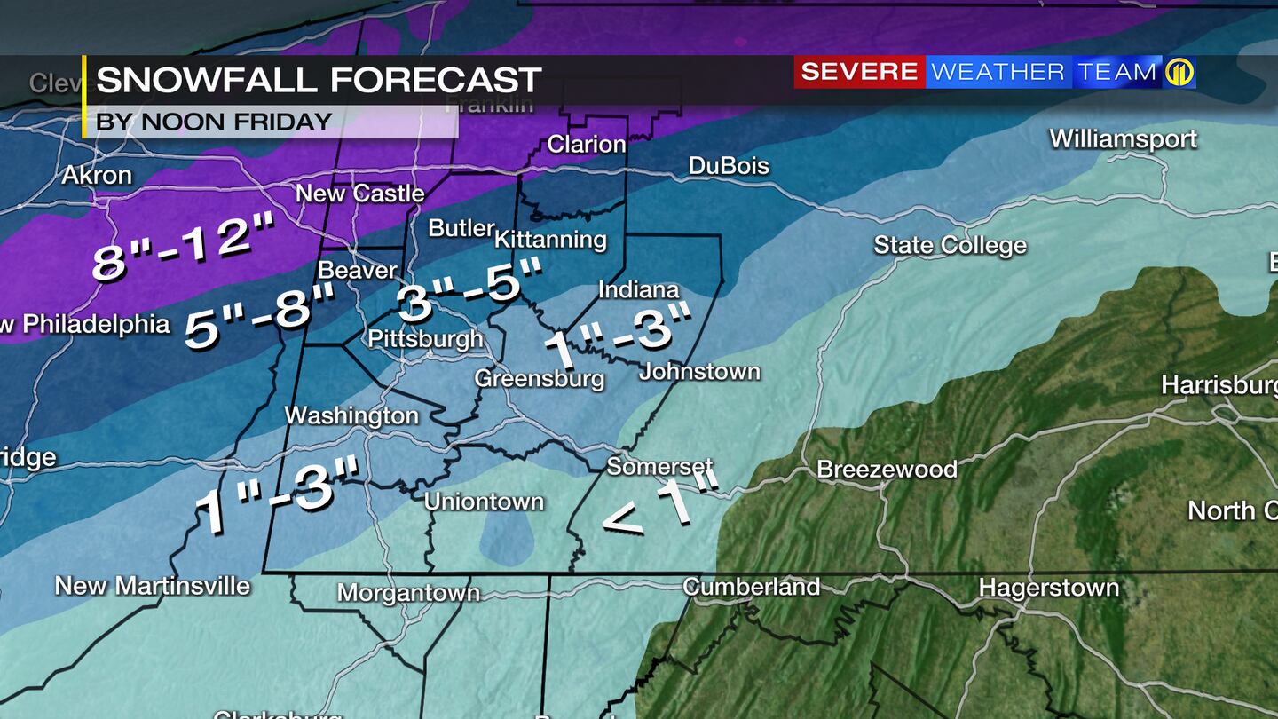
Wrap up your errands early today. Rain has overtaken much of the area, and that rain will slowly change to a wintry mix and then snow from northwest to southeast across the area.
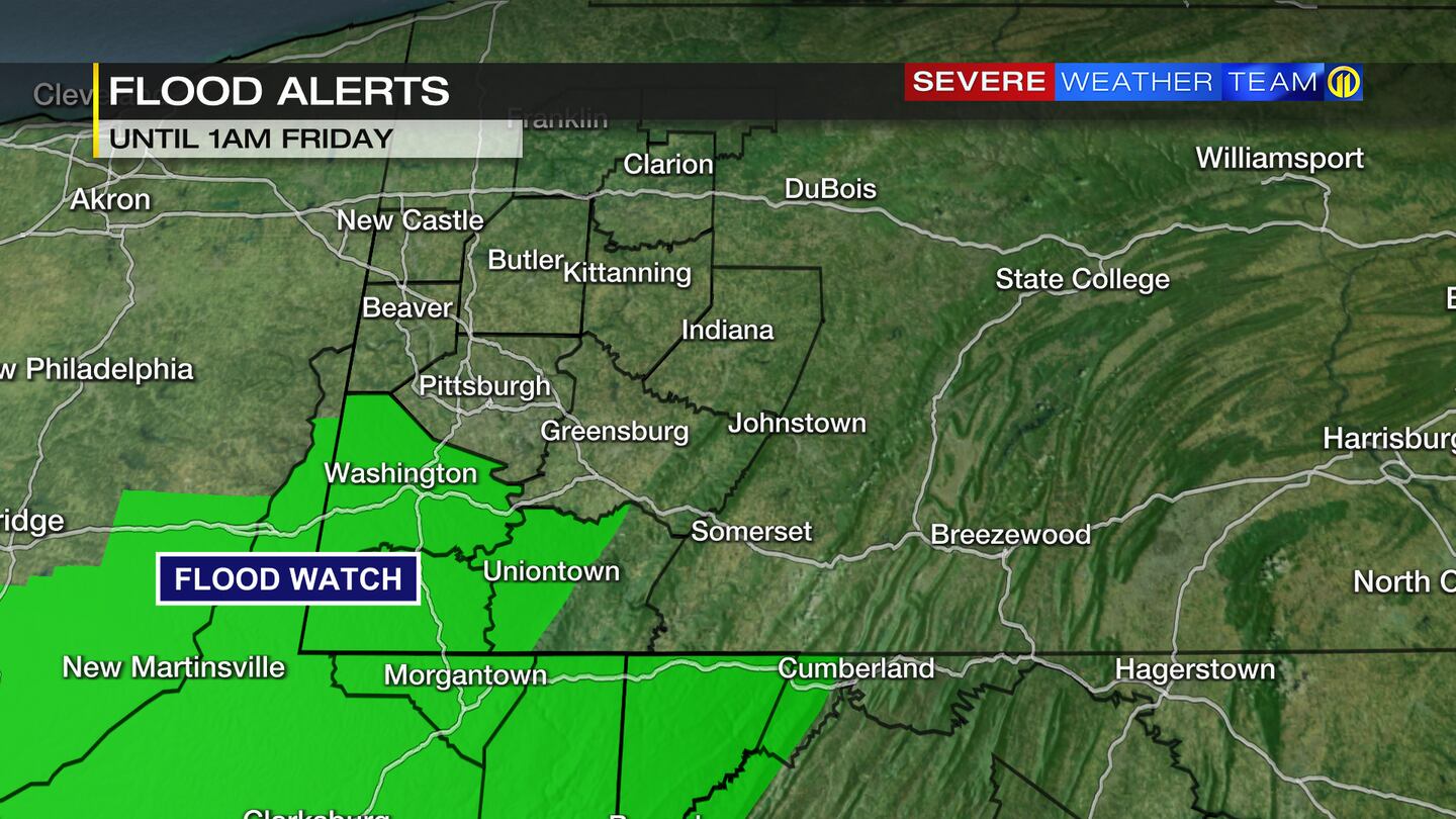
Rain could lead to localized flooding due to the snowpack and recent runoff. A Flood Watch is in effect for Washington, Greene, western Fayette, Monongalia, Preston and Garrett counties until 1 a.m. Friday.
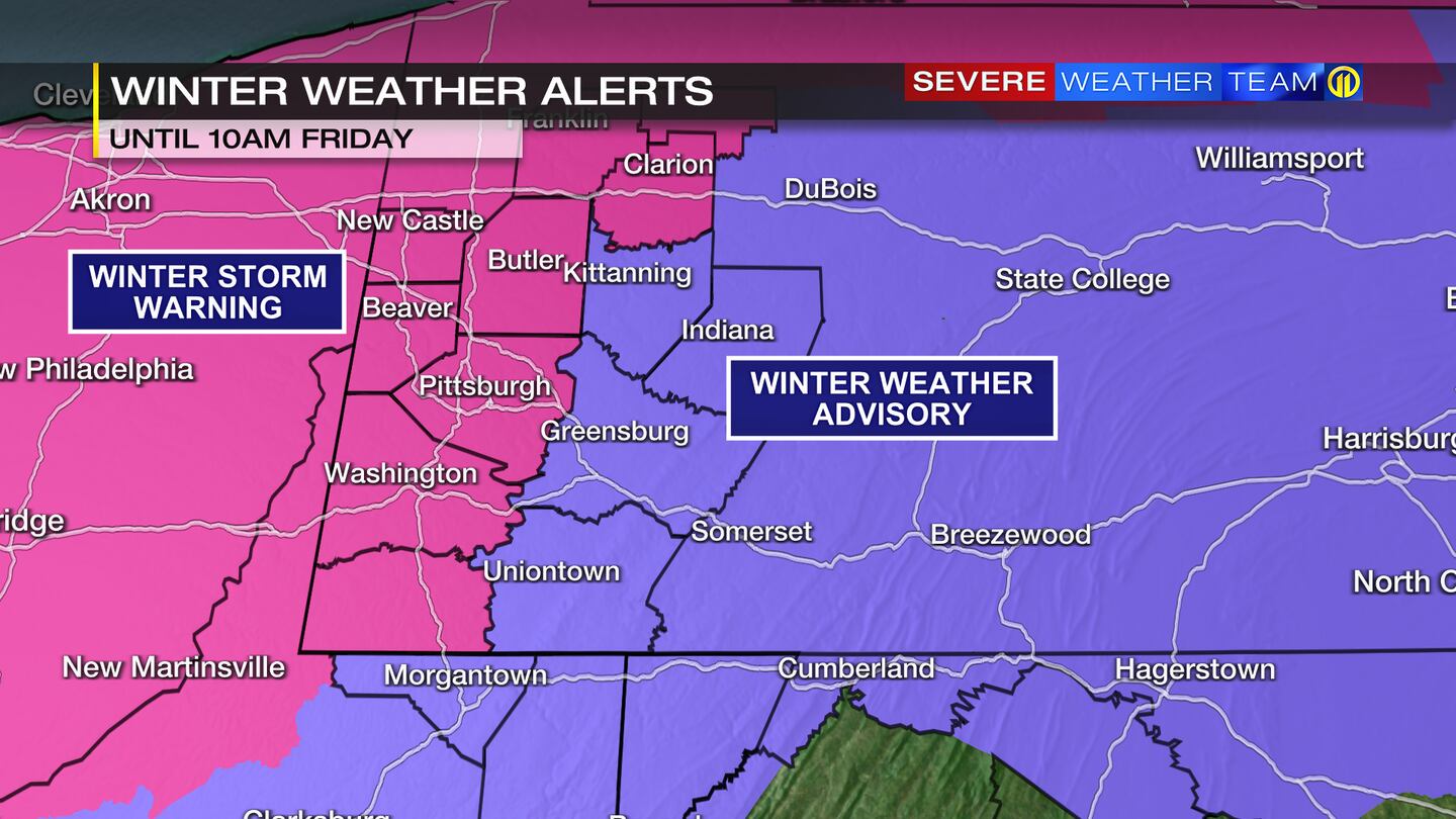
Icy conditions will be likely northwest of Allegheny County during the day Thursday as a wintry mix of freezing rain, sleet and snow pushes into the area from the northwest.
Travel will be dangerous Thursday night and Friday morning as much of the area transitions to a mix of freezing rain and sleet before changing to snow.
>>WATCH: Trisha’s Traffic Hacks: Driving, stopping in winter weather
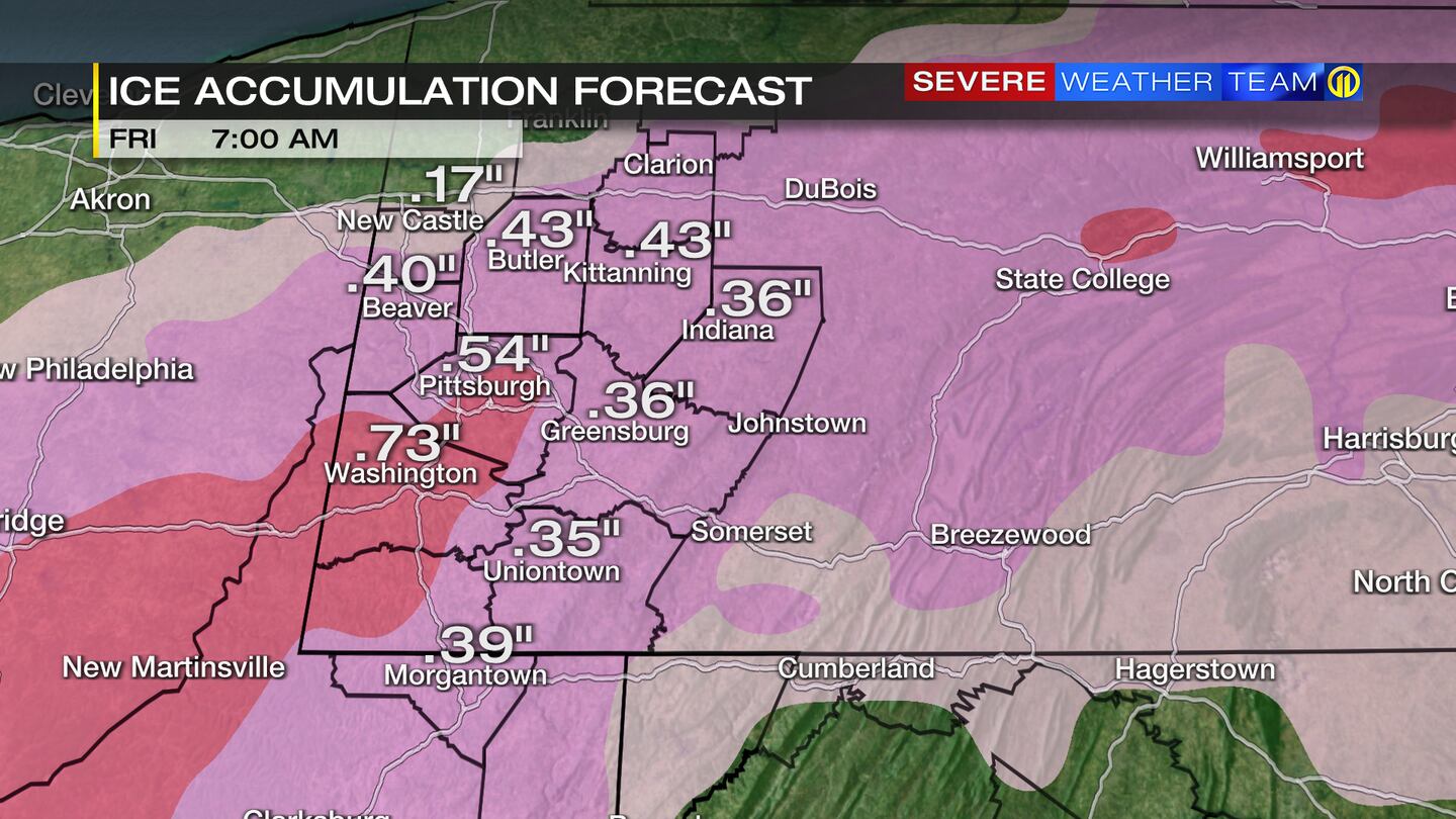
A couple of inches of snow will accumulate on top of the ice by Friday morning.
Power outages could be a problem for much of the area.
>>RELATED STORY: Road crews getting ready for messy winter storm targeting western Pennsylvania
Here’s a full breakdown of the expected timeline.
SEVERE THREAT:
-Dangerous travel late Thursday, Thursday night and Friday to icing and snow. Power outages likely.
IMPACTS:
-1″+ rainfall through Thursday could lead to flooding issues due to the snowpack (not FLASH flooding but urban flooding)
-Transition from rain to freezing rain/sleet Thursday will make travel dangerous and create power outages (especially late in the day and night)
-Wintry mix changing to snow Thursday night will create a skating rink under a few inches of snow
-Heavy accumulation of snow will be possible in our northwestern communities (6″+ by Friday morning)
-Pittsburgh could have 2″-4″ of snow by mid-morning Friday on top of anything iced over
>>RELATED STORY: Here are 7 winter driving tips
The details of how this storm develops are still coming into focus, so check out the live Severe Weather Team 11 forecast updates on Channel 11 often.
TRENDING NOW:
©2021 Cox Media Group
/cloudfront-us-east-1.images.arcpublishing.com/cmg/XCUXZC2XYZHCRGNNGKFEX6U3LQ.png)


